WikiProject Belgium/Road completion project/Instructions
This page contains instructions for the first task in the Belgian Road completion project.
For a general intro, head to the OpenStreetMap Belgium Project page.
More about the project on our wikipage.
Getting started
Go to MapRoulette and log in with your OpenStreetMap account. You may first be prompted to login to OpenStreetMap, then you will need to approve MapRoulette to connect to your account.
You can now start the mapping. Please read the instructions carefully before continuing.
Basic instructions
After you've logged in to MapRoulette, open one of our MapRoulette challenges. You need to log in to see the task.
- Bruxelles/Brussel (Brussels), Belgium : https://maproulette.org/browse/challenges/14675
- Vlaanderen (Flanders), Belgium : https://maproulette.org/browse/challenges/14645
- Wallonie (Wallonia), Belgium : https://maproulette.org/browse/challenges/14681
MapRoulette randomly selects a task, indicated by the blue line.
Click Edit to open the task in your favorite editor.
Make sure to follow these rules:
- If you're not sure, don’t map it, close your editor and choose "Skip". Someone else will try and fix it for you.
- If it’s a public road missing in OSM, add it to map as you would any road and choose "I fixed it" in MapRoulette.
- If it’s a driveway missing in OSM, add it to the map as you would any "driveway" (or NL: “oprit”) in the default iD editor (or use tags, like with the JOSM editor). Don’t add a street name! Add an access=private tag if needed, because this is not the default. Choose "I fixed it" in MapRoulette.
- If you think there is nothing wrong in this area choose "Not an issue", you may add a comment.
Don't forget to 1) save your changes to OpenStreetMap with your editor as well as 2) indicate what you fixed to MapRoulette. Note that some people do not like all the driveways to be mapped in OSM. If you map them, make sure they are properly marked as private. If you choose not to map them, remember that the next mapper might add it anyway, and maybe with less attention for detail than you would.
More mapping tips
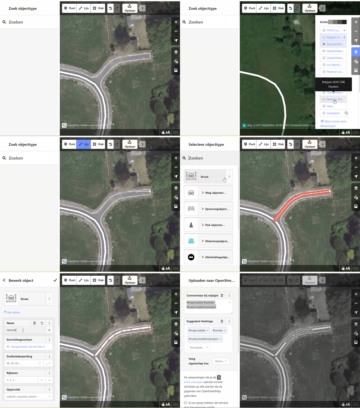
Click Edit to open the task in your favorite editor. The default is iD. A new window will open. Trace the missing road with the best imagery (Belgium AGIV Orthophoto, for Flanders). We don't offer you the original geometry, because we want to force you to think for yourself.
To decide the kind of road it is, have a look at the different available imagery sets. "Belgium AGIV Orthophoto" will usually be the best for Flanders. "Belgium AGIV GRB Flanders" is the Flemish Basemap. In principle, GRB should never contain driveways (Dutch).
- If the street name is not the same on the GRB map and the MapRoulette task, don't add the name. But please leave a comment in MapRoulette, so we can communicate the error to the local government. In the future, we will also make tasks specifically to check street names.
- Normally, there shouldn't be any paths in the results - but it does happen. If there are, you can map them. But make sure they really exist: they should be clear on the imagery and/or visible in the GPS data layer.
If in doubt: don’t map it! there are plenty of mistakes in the Wegenregister data.
If you’re sure about what you’re doing: save your change. When saving, a changeset comment will already be filled in for you. Please respect what it says, as it helps with tracking edits. (If you use JOSM, and it is not prefilled, use #osmbe #roadcompletion #maproulette). If you did anything more than asked, please add a very short description of that to the changeset comment. Now close the editor to return to the challenge.
In MapRoulette, choose between “I fixed it”, “Too difficult” and “Already fixed”. Use “Too difficult” if you’re not sure. If you think we shouldn’t have offered this road at all, click "Not an Issue". If there is anything special about the task, leave a Comment before moving on.
If you need help, contact us by mail through community@osm.be, on Twitter or on our Riot chat channel.
Advanced tips
If you can add a road, but some details should still be verified, you should leave a Comment in Maproulette. You could also add a fixme tag with some info for local mappers.
