FR:OsmAnd
| OsmAnd | |
|---|---|
 | |
| Auteur : | Victor Shcherb et les contributeurs |
| Licence : | GPL v3 et artwork and design elements CC-BY-ND-NC (gratuit ou 24.99€) |
| Plateformes : | Android et iOS |
| Version : | 4.7.1 versions (2024-02-06) |
| Langues : | anglais, russe, allemand, français, arabe, bulgare, bosniaque, tchèque, danois, espagnol, basque, finnois, hébreu, hindi, hongrois, arménien, indonésien, italien, japonais, géorgien, coréen, italien, letton, marathi, néerlandais, norvégien, polonais, portugais, portugais brésilien, roumain, slovaque, serbe, suédois, ukrainien, vietnamien et chinois |
| Site Internet : | https://osmand.net |
| Installation : | |
| Code source : | osmandapp |
| Langages de programmation : | Java et C++ |
|
Navigation (routage) hors ligne et en ligne, affichage de cartes OSM et autres (vectorielles ou tuiles, stockées, en cache ou en ligne, POI et recherche d'adresses (hors ligne ou en ligne avec Nominatim), soumission de bugs OSM et de POI, favoris/marques, informations sur les transports en commun. Développement actif. Mots clés : GPS navigator, GPS navigation, navigation system, satellite navigation, sat nav, satnav, GPS tracker, GPS tracking, GPS map, OpenStreetMap, OSM viewer, map viewer, OSM mapping, offline routing, offline world map, global offline country maps, outdoor. | |
OsmAnd est une application de consultation de carte et navigation GPS fonctionnant sur la plupart des smartphones et tablettes Android et IOS, et qui propose en option un routage des des cartes hors-ligne.
OsmAnd est un projet collaboratif et open source (GPS) qui intègre les données 100% libres OpenStreetMap afin de proposer une solution GPS mobile complète et facile d'emploi.
Bien qu'utilisant des données 100 % libres, l'achat de la version pro ne peut se faire que par Google ou Amazon.
OsmAnd permet la consultation de cartes, la navigation, le routage, prend en charge les Points d’Intérêt (POI) ainsi que l'enregistrement de traces. C'est un logiciel fiable et abouti, qui fonctionne sur la plupart des tablettes & smartphones Android / IOS, ainsi que de nombreux systèmes basés sur Linux.
Les cartes et points d'intérêt, régulièrement mis à jour, sont téléchargées et stockées localement sur l'appareil. Le fonctionnement ne nécessite alors plus de connexion internet, ce qui permet une utilisation illimitée sans surcoût de données mobiles. OsmAnd permet également une localisation GPS sans interruption même dans les zones avec peu ou pas de réseau mobile (zones blanches).
OsmAnd et la base de données OpenStreetMap vont même au-delà des fonctions habituelles d'un GPS. Les informations géo-démographiques provenant de sources comme Wikipedia peuvent être intégrées et affichées sur le fond cartographique en tant que Points d'Intérêt (POI). Le niveau de détail et la richesse de la base de POI sont la plupart du temps supérieurs à ceux des systèmes commerciaux, habituellement fermés et non-évolutifs.
Enfin, le système entier, les données cartographiques et le logiciel sont open source et collaboratifs. Tout utilisateur, après une inscription totalement gratuite et qui prend moins de deux minutes, peut corriger des erreurs sur OpenStreetMap, compléter les POI, signaler un bug sur OsmAnd, ou faire une suggestion d'amélioration. L'association d'OsmAnd et OpenstreetMap répond tout à fait l'évolution actuelle des besoins en termes de GPS sur mobile.
Téléchargement & installation
Dans la plupart des cas il est recommandé de passer par sa logithèque habituelle (ex : Play Store, F-droid, App Store ...) afin de bénéficier des mises à jour automatiques.
Langues supportées : Arabe, Chinois, Tchèque, Néerlandais, Anglais, Français, Allemand, Grec, Hébreu, Hindou, Italien, Japonais, Coréen, Polonais, Portugais, Russe, Espagnol, Tagal, Vietnamien... (liste non exhaustive et évolutive)
Version gratuite OsmAnd
Dernière version à jour du logiciel, limitée à 7 téléchargements de cartes, et sans intégration des POI Wikipédia :
Version payante OsmAnd+
Version communautaire OsmAnd~
Version complète sans aucune limitation, maintenue par F-Droid
https://f-droid.org/fr/packages/net.osmand.plus/
Version de développement (nigthly build)
Dernière version expérimentale, à installer manuellement. Peut se révéler instable, et n'est pas mise à jour automatiquement.
Autres versions
Pour plus de versions et autres projets, visitez la page officielle de téléchargement d'OsmAnd : downloads page.
Si vous choisissez une version gratuite, veuillez soutenir le projet d'une autre manière, par exemple en achetant des objets publicitaires.
La base de données OpenStreetMap et l'application OsmAnd
OpenStreetMap et OsmAnd sont deux grands projets ouverts ; en conséquence, il convient de distinguer les questions relevant des données OSM et celles relatives au logiciel OsmAnd. Par exemple, les problèmes de données manquantes ou erronées au niveau de la cartographie (connexion de chemins, valeurs ...) peuvent engendrer une navigation inefficace ou tout au moins non-optimale de la part d'OsmAnd. À partir du moment où le fond de carte est juste et complet, l'application OsmAnd donne les résultats attendus.
Les tuiles de cartes d'OsmAnd sont mises à jour régulièrement, avec chaque fois des centaines voire des milliers d'ajouts et corrections. Les points d'intérêt (POI) en particulier demandent une veille constante pour rester pertinents et précis, compte-tenu des nombreux déménagements, créations et fermetures d'établissements chaque mois. Il est très facile de contribuer à la correction de la carte. Vous pouvez déjà simplement signaler les problèmes constatés, c'est déjà très utile en soi. Vous pouvez aussi remonter vos manches et éditer directement la carte. Après vous être inscrit (procédure très rapide en deux minutes), vous pourrez utiliser des outils très simple d'emploi pour modifier les données.
Merci pour votre contribution à cette lourde tâche qu'est la maintenance à jour des données OpenStreetMap.
OsmAnd n'utilise pas le rendu OSM standard (aussi appelé openstreetmap-carto) pour générer ses tuiles. L'application utilise son propre moteur de rendu. Ainsi les bugs relatifs au rendu de carte doivent être signalés sur OsmAnd-resources GitHub project.
Support OpenStreetMap et aide (données et serveur)
- FAQ - Foire aux questions.
- Wiki - Documentation plus complète.
- Forum - Pour les discussions et échanges entre utilisateurs. Voir aussi "Help Desk".
- Help Desk - Pour des questions non déjà traitées par ailleurs.
- Mailing Lists - Pour les discussions à plus long terme. Différentes listes par zones / pays.
Support OsmAnd
OsmAnd est un projet de grande envergure avec des millions d'utilisateurs de par le monde. Pourtant, cette application et de la base de données sur laquelle elle s'appuie, reposent sur un nombre restreint de contributeurs qui œuvrent à leur qualité. S'il vous arrive de rencontrer un problème et que vous arrivez à le surmonter, merci de nous aider à mettre à jour la FAQ, le Wiki, les pages du forum, etc., et de lier la solution aux éventuelles questions posées. Faites en sorte que la prochaine personne qui rencontrera le même problème ait accès à la solution. Aidez les développeurs à documenter le fonctionnement d'OsmAnd, et proposez des exemples concrets d'utilisation. Si vous avez des compétences de programmation en Java, vos contributions sont également bienvenues.
Un support de qualité et durable dans le temps nécessite de nombreuses mains. Merci de contribuer selon vos moyens, en aidant et/ou financièrement.
Aide aux utilisateurs d'OsmAnd
- Site officiel d'OsmAnd : copies d'écran, aperçu des fonctionnalités, blog et documentation.
- Wiki officiel OsmAnd : C'est la page que vous êtes en train de lire. Il fut un temps où d'autres sites (comme Google Code) hébergeaient le wiki, mais depuis 2015 tout est redirigé ici.
- Google Groups Forum (Osmand) : Échanges entre utilisateurs. C'est le bon endroit pour faire des suggestions de fonctionnalités.
Aide aux développeurs d'OsmAnd
- OsmAnd repose sur deux bases :
- Osmand-java : une bibliothèque 100% java, multi-plateformes, non liée à Android.
- Osmand : version spécifique Android. Elle utilise différentes bibliothèques Android, qui sont en perpétuelle évolution. Nous avons besoin d'aide pour maintenir leur implémentation.
- Aide et documentation technique
- Application GitHub Issue Tracker
Fonctionnalités
OsmAnd est une application de cartographie et de navigation qui utilise la base de données mondiale libre OpenStreetMap.
Toutes les données peuvent être stockées localement sur la mémoire de votre appareil pour usage hors connexion.
Grâce à la puce GPS de votre appareil, OsmAnd permet le routage d'itinéraires, avec guidage visuel et vocal, en modes voiture, vélo et piéton. Toutes les fonctions, y compris la navigation, peuvent être utilisées en mode connecté ou hors connexion.
OsmAnd+ est la version payante de l'application. En achetant OsmAnd+ vous soutenez le projet et le développement de nouvelles fonctionnalités.
Liste des principales fonctions :
- Fonctionnement en-ligne (rapide) ou hors-connexion (pas de frais de connexion à l'étranger)
- Guidage vocal pas à pas (voix de synthèse TalkBack et voix enregistrées)
- En option, guidage "lane and turn", affichage du nom des rues et estimation de l'heure d'arrivée
- Points d'intérêt sur l'itinéraire
- Recalcul de l'itinéraire automatique si vous déviez
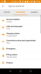
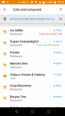
- Recherche de points d'intérêt par nom (ex.: restaurant, hôtel, station d'essence, musée), catégories, coordonnées géographiques ou le long de l'itinéraire
- Marquage de route barrée
Consultation de carte
- Affichage de la position courante et de l'orientation d'après la boussole
- Option centrage de la carte et orientation d'après le sens de déplacement
- Sauvegarde d'emplacements (favoris et marques)
- Affichage des points d'intérêt à proximité
- Affichage de cartes en ligne
- Affichage de la vue satellite (Bing)
- Affichage en surcouche : itinéraires référencés, traces GPX
- Prononciation des noms de lieux en anglais, en langue locale ou lettre à lettre
- Différents rendus (fonds de carte) disponibles
Intégration de Wikipédia
- High quality information from the two best collaborative projects of the world : OpenStreetMap and Wikipedia.
- Great for touring, sightseeing, and historical backgrounding. Discover new information about the places right around you, or around your family, relatives, associates, etc., even abroad.
- Rapidly become locally acclimated.
- Great way to liven up long trips, learning about the numerous interesting places right along your route.
- WikiPedia server sites tag millions of places around the world with geo tags (latitude/longitude coordinates), these often include cities, towns, villages, historic places, museums, civic centers, etc.
- OsmAnd Plus (the low cost paid version) includes unlimited map downloads and unlimited downloads of condensed WikiPedia place data files, formatted for immediate use in OsmAnd plus map files as Points of Interest (POI)
- WikiPedia places (when downloaded and enabled in OsmAnd plus under Configure Map, POI, WikiPedia (offline)) show up on maps as unobtrusive circles with W inside.
- Briefly touch a W and get a one-line description of that WikiPedia place
- Touch a W a bit longer the name pops up inside a small gray box. Then, just :
- tap the red X to remove that pop up, or
- tap anywhere inside that gray box to bring up a new comprehensive menu. Select either:
- Show POI description This brings up several sentences, sourced from WikiPedia, describing the place. An Internet connection is NOT required, and no data charges will ever accrue.
- Show POI Website this option will take you (via the browser of your choice) directly to the relevant WikiPedia article page. (An Internet connection is required, and your provider may charge you their data transport fees.)
- It's very easy to set the selected POI location as a destination, get directions, save to a favorite for use later, etc.
- WikiPedia places are constantly being updated. Coverage in many areas is outstanding.
- WikiPedia POI files (places) are currently available by WikiPedia site language and not limited by geographic region.
- For example the English WikiPedia file includes places found in the English language WikiPedia servers, including USA, UK, Canada, much of English speaking EU, etc. It also includes coverage of non-English speaking places to the extent they are included in the English language WikiPedia site. (For example the English language WikiPedia covers Paris, Hong Kong, Berlin and many other places throughout the world, discussing those places in English.)
- WikiPedia files can be quite large. The English WikiPedia file is about 300 MB to download and expands to about 1 GB when decompressed.
- These files (and all the OsmAnd map files) may typically be run from your main, or SD memory storage, or from an auxiliary (add-on) memory card (provided your device has a slot for one and most do), even if you do not have root access to your Android operating system. Where the files are stored is easily configured via a menu option, and the software will effortlessly move any existing downloaded files to a new location you choose.
Safety features
- Optional automated day/night view switching
- Optional speed limit display, with reminder if you exceed it
- Optional speed-dependent map zooming
- Share your location so that your friends can find you
Bicycle and pedestrian features
- The maps include foot, hiking, and bike paths, great for outdoor activities
- Special routing and display modes for bike and pedestrian
- Optional public transport stops (bus, tram, train) including line names
- Optional trip recording to local GPX file or online service
- Optional speed and altitude display
- Display of contour lines and hill-shading (via additional plugin)
Elevation data is not (yet) used for routing but may be considered when using an external routing engine such as BRouter
Directly contribute to OpenStreetMap
- Report map bugs
- Upload GPX tracks to OSM directly from the app
- Add POIs and directly upload them to OSM (or later if offline)
- Optional trip recording also in background mode (while device is in sleep mode)
OsmAnd is open source and actively being developed. Everyone can contribute to the application by reporting bugs, improving translations, or coding new features. The project is in a lively state of continuous improvement by all these forms of developer and user interaction. The project progress also relies on financial contributions to fund the development, coding, and testing of new functionalities. By buying OsmAnd+ you help the application to be even more awesome ! It is also possible to fund specific new features, or to make a general donation on osmand.net.
Strengths and weaknesses
Strengths
- Open Source (GNU GPL Version 3), although some features are not free and visual elements are CC BY-NC-ND 2.0[1]
- Possibility to use and edit maps completely offline and no time use limitations, like google maps for example
- Store for offline use vector maps and raster satellite images from various sources
- No ads, except one suggesting to buy paid version in configuration to get some paid features
- No trackers, although it has some analytics off by default, the user has the option to share with developers: only downloaded maps and screens visited. No location and position data is ever shared.
- No abusive permission requests, only ask permissions to use the related resource like: GPS location to use it, storage access to save maps, internet access to download maps, camera access to take photos, audio access to record audio...
- Very good customizable options shown during navigation like lanes, radar, max speed...
- Shows Wikimedia Commons and Mapillary images in POIs (only online)
- Can store offline maps and other data in SD card in Android version[2]
- In POI details: quick phone call with just 2 taps, search nearby similar POIs, email and HTTP links, copy coordinates in 7 formats
- Also available in Android Go, an Android version for low resource devices, although the vector maps view is slow
- Save photo, video and audio notes[3]
- Add quickly a POI with certain configured tags (fixed tags and fixed values or fixed tag and values prompt to enter data)[4]
- Quick and simple upload changes to OpenStreetMap (POIs, notes and tracks)
Weaknesses
- No live traffic data
- No 3D view
- Limited voice instructions in embedded pre-recorded voices, but synthesized TTS (text to speech) voices can be used and are better maintained[5]
- Very confusing options and configurations although it has a "clean" main screen interface
- Slow in some older smartphones
- Limited support to areas (can edit only tags in some areas) and relations (only shows route relations associated to POIs)
- A bit limited in some edits to upload to OpenStreetMap like: no tag presets, no edits in way tags
- Doesn't support radar relations, only radar POIs/nodes, but is a planned feature
- Limited in very long routes in offline app calculation, like 200km or more, although possible with Third-party routing (BRouter) [6]
- Always shows the best route according to configuration like avoid tolls, unpaved roads, but not alternative routes
Some advanced fragments of information about OsmAnd offline vector map data
- offline map data files that can be used with OsmAnd have *.obf as file extension.
- in latest versions of these map files all vector map data, POIs and address indexes for offline search are included.
- you can generate your own *.obf files by using OsmAndMapCreator.
- when you have several *.obf files for single regions of a certain country, you can combine them with inspector.bat or inspector.sh that is delivered with OsmAndMapCreator. Start this script on a command line without any parameters to see all options and proceed.
- Maybe there is a named street in the OSM data, but OsmAnd cannot find it via its offline address search? Run the above mentioned inspector with parameter -v and [nameofyourmapfile].obf >list.txt ... this will give you a text file with all places that are within that obf file and all streets that are associated to that place. Thus you can find out whether OsmAnd's street list is incomplete (this can have several reasons like missing administrative borders etc.)
Examples of OSM POI categories supported in OsmAnd
Wherever OpenStreetMap POI categories are known to be rendered and/or searchable in OsmAnd, its corresponding key or tag page should indicate that OsmAnd supports it.
- food (bar, bbq, biergarten, cafe, drinking_water, fast_food, food_court, pub, restaurant)
- education (college, kindergarten, library, school, university)
- emergency (access_point, ambulance_station, fire_extinguisher, fire_flapper, fire_hose, fire_hydrant, fire_station, phone, police, ses_station, siren)
- transportation (bicycle_parking, bicycle_rental, bus_station, car_rental, car_sharing, car_wash, ferry_terminal, fuel, grit_bin, parking, taxi)
- finance (atm, bank, bureau_de_change)
- healthcare (baby_batch, dentist, doctors, first_aid, hospital, pharmacy, veterinary)
- entertainment (architect_office, arts_centre, brothel, cinema, community_center, fountain, nightclub, sauna, stripclub, studio, theatre)
- tourism (alpine_hut, artwork, attraction, camp_site, caravan_site, chalet, guest_house, hostel, hotel, information, motel, museum, picnic_site, theme_park, viewpoint, zoo)
- historic (archaeological_site, battlefield, boundary_stone, castle, fort, memorial, monument, ruins, wayside_cross, wayside_shrine, wreck)
- natural (bay, beach, cave_entrance, cliff, coastline, fell, glacier, heath, land, marsh, mud, peak, sand, scree, scrub, spring, stone, tree, volcano, water, wetland)
- shop (alcohol, bakery, beauty, beverages, bicycle, books, boutique, butcher, car, car_repair, charity, chemist, clothes, computer, confectionery, deli, department_store, doityourself, dry_cleaning, electronics, fabrics, farm, florist, funeral_directors, furniture, garden_centre, general, gift, glaziery, greengrocer, hairdresser, hardware, hearing_aids, hifi, ice_cream, jewelry, kiosk, laundry, mall, massage, money_lender, motorcycle, newsagent, optician, organic, outdoor, pawnbroker, second_hand, shoes, sports, stationery, supermarket, tattoo, toys, travel_agency, variety_store, video)
- leisure (common, dance, dog_park, fishing, garden, golf_course, ice_rink, nature_reserve, marina, miniature_golf, park, pitch, playground, sports_centre, slipway, stadium, track, water_park)
- sport (10pin, archery, athletics, australian_football, baseball, basketball, beachvolleyball, boules, bowls, canoe, chess, climbing, cricket, cricket_nets, croquet, cycling, diving, dog_racing, equestrian, football, golf, gymnastics, hockey, horse_racing, ice_stock, korfball, motor, multi, orienteering, paddle_tennis, paragliding, pelota, racquet, rowing, rugby, shooting, skateboard, skating, skiing, soccer, swimming, table_tennis, team_handball, tennis, toboggan, volleyball)
- other (bench, clock, courthouse, crematorium, embassy, emergency_phone, fire_hydrant, fire_station, grave_yard, hunting_stand, internet_access, marketplace, place_of_worship, police, post_box, post_office, prison, public_building, recycling, shelter, telephone, toilets, townhall, vending_machine, waste_basket, waste_disposal)
Contribute to OSM via OsmAnd
OsmAnd supports directly contributing to the OSM database, both online and offline. Corrections are either uploaded to the OSM database instantly, or in offline mode, must be manually uploaded later.
First, you will need to register with OSM.
Then, in OsmAnd go to Menu > Plugins and activate OSM Editing plugin.
Finally, go to Menu > Plugins > OSM editing > Settings and enter your account data (OSM user name and password).
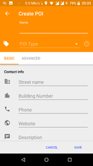
To add a POI
- Tap (long tap) on a location on the map you want the POI to appear.
- Tap on "Actions".
- Select "Create POI".
- Select a POI type.
- Type in the information in each of the fields.
- To add more advanced tags:
- Select "Advanced Mode".
- Select "Add Tag".
- Type "A" in the tag box. You can't see the whole field, so you just have to remember what spot each value is in.
- Type the value in.
- Finally tap "Save".
- You can select your added POI now and tap "Upload" to directly send the POI to OSM.
If you want to add more than one POI and upload afterwards, this is also possible. Add the POIs you want to the map and not upload them directly. To upload all POIs you have create, tap on Menu > My Places. Switch to the tab "OSM Edits". Here you can select all POIs you want to send to OSM and upload them.
To edit a polygon
[this section is empty or needs expanding]
See issue 5595.
To record and submit GPX tracks
- Go to Menu > Plugins and activate the Trip recording plugin.
- Go to the map and tap the button labeled REC in the top-right corner of the screen, next to the button with the satellite dish. This will start recording your trip.
- When you have finished your trip, tap the button again to stop recording.
- Go to Menu > My Places > Tracks.
- Find the recorded track, and tap on it to get its menu and tap on Options (3 dots on right hand side)
- Select Upload to OpenStreetMap
- Edit details if required and tap Upload
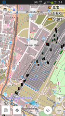
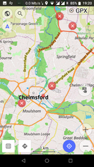
Screenshots
- OsmAnd for Android
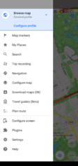
Main menu
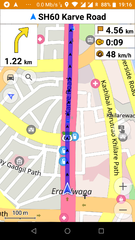
Car navigation
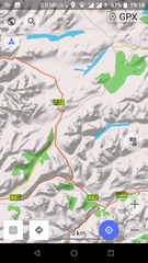
Map with hillshades layer
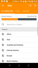
Download offline maps

Route details
Modify/create POIs (offline)
General Search (offline - osmand supports nomintim searches too)
Nearby POI with opening hours
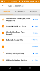
Search history
Railway signals from OpenRailwayMap as an overlay
See/edit OSM bugs


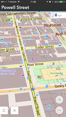
- OsmAnd for iOS
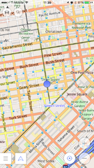
2D overview map
3D overview map

Search results


Customizing OsmAnd
Create your own maps
See the help topic Create Offline Raster & Vector Maps and OsmAndMapCreator
Custom rendering style
OsmAnd already contains a number of specialized Map styles, from the map screen check them out by tapping the devices menu button, select "Define View", then "Configure screen", examples are the "Touring view" map style allowing some advanced options for options for hiking and bike tours, or the "Winter+ski" map style for skiing trips.
You may also define your own map style. This is a bit involved, please check out our forum, our HowTo pages, and start from the depends rendering template. Edit the file as you wish, rename it XXX.render.xml and place it on your device under /sdcard/osmand/rendering. Then in Osmand select XXX under "Map style".
Custom Routing Parameters
Just as with rendering, it is possible to change the parameters used by the routing engine. This can be done by editing `routing.xml` and placing it next to the maps. This is all documented in the original routing.xml.
Desktop Viewer for OsmAnd maps
An early version of a Desktop viewer for OsmAnd maps can be downloaded from Sourceforge: https://sourceforge.net/p/offroadosm/wiki/Home/
Notes et références
Ressources et liens externes
- Site officiel d'OsmAnd
- Visualisation de la carte OsmAnd
- Tuto complet OsmAnd pour les randonneurs
- Groupe Google OsmAnd
- Liste des index locaux OsmAnd : liens vers les ficheirs .obf
- BBBike.org extract service offers OsmAnd maps for an area of your choosing, weekly updates
Anciens articles
- 2014: Using Osmand on the road : blog post about setting up Osmand on your smartphone
| ||||||||||||||||||||||||||||||||||