File:Autorizacao IPPUC.pdf
 Size of this JPG preview of this PDF file: 424 × 600 pixels. Other resolutions: 170 × 240 pixels | 339 × 480 pixels | 543 × 768 pixels | 1,239 × 1,752 pixels. |
Original file (1,239 × 1,752 pixels, file size: 156 KB, MIME type: application/pdf, 3 pages)
Summary
| Description | Capture of the e-mail sent by IPPUC (Institute of Research and Urban Planning of Curitiba), where the use of their data is authorized on OpenStreetMap. |
|---|---|
| Author | matheusgomesms |
| Source | Own |
| Date | 2024-01-25 |
English
Message Transcript and translated:
Dear IPPUC Civil Servants, good morning!
I am part of the OpenStreetMap Brazil (OSM-BR) community, and I would first like to congratulate IPPUC's high-quality data, open to the community, as well as thank the long-standing partnership with OSM-BR.
We have already carried out some projects in Curitiba, using IPPUC data, and we want to focus more on the city, improving OSM data. For this, it would be very useful to also use the IPPUC orthophotos.
To do this, I would like to confirm whether we can actually also use the IPPUC orthophotos via WMS/GeoServer. Initially we have plans to map sidewalks, and high-resolution photos and correct positioning would help us a lot.
A simple confirmation via email would be enough. I also make myself available for any questions.
Thank you very much in advance!
Yours sincerely,
Matheus Gomes
IPPUC response
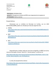
PROTOCOL: 00-001841/2024
SUBJECT: Use of IPPUC orthophotos for mapping sidewalks, etc.
INTERESTED: Matheus Gomes
Dear Matheus
We inform you that the orthophotos of the Municipality of Curitiba, year 2019 (Orfotos2019_RGBN), can be used through the following links:
• PORTAL https://geocuritiba.ippuc.org.br/portal/home/item.html?id=1823e498f03e48a3a757b59fdf3d00aa
• REST https://geocuritiba.ippuc.org.br/server/rest/services/GeoCuritiba/Ortofotos2019_RGBN/ImageServer
We also make data available from our cartographic base, in REST, with various levels of information, including "curb" and "walking area", according to the link: https://geocuritiba.ippuc.org.br/server/rest/services/GeoCuritiba/Publico_Interno_GeoCuritiba_BaseCartografica_para_MC/MapServer
And, also, urban equipment: https://geocuritiba.ippuc.org.br/server/rest/services/Publico_GeoCuritiba_Equipamentos_Urbanos/MapServer
We are available for any additional clarifications:
geoprocessamento@ippuc.org.br or
55 (41) 3250-1352.
Curitiba, January 25, 2024.
Yours sincerely,
IPPUC/DIN/Geoprocessing Sector
Português
Captura da mensagem de e-mail emitido pelo IPPUC (Instituto de Pesquisa e Planejamento Urbano de Curitiba), onde se autoriza o uso dos seus dados no OpenStreetMap.
Transcrição da mensagem:
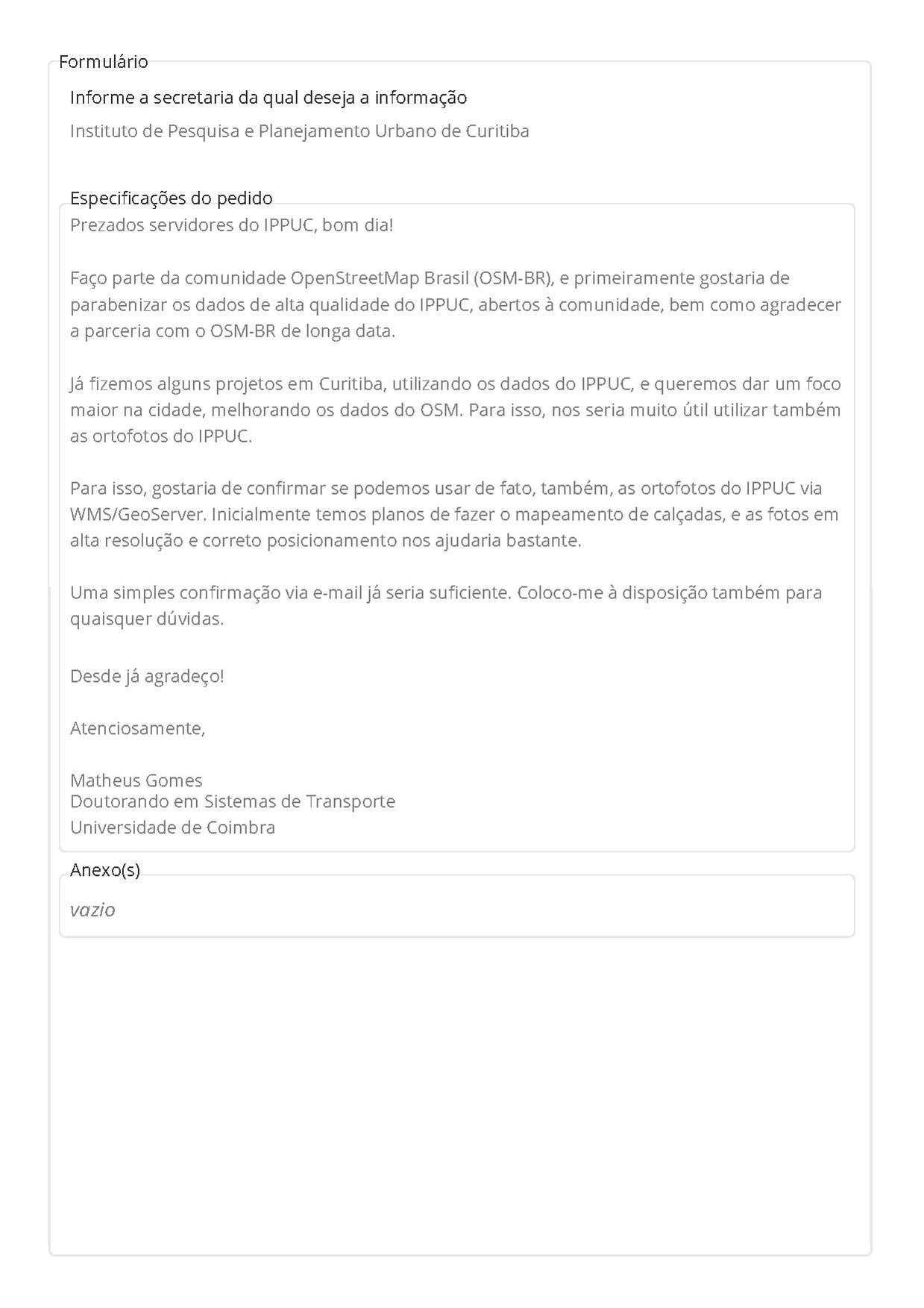
Prezados servidores do IPPUC, bom dia!
Faço parte da comunidade OpenStreetMap Brasil (OSM-BR), e primeiramente gostaria de parabenizar os dados de alta qualidade do IPPUC, abertos à comunidade, bem como agradecer a parceria com o OSM-BR de longa data.
Já fizemos alguns projetos em Curitiba, utilizando os dados do IPPUC, e queremos dar um foco maior na cidade, melhorando os dados do OSM. Para isso, nos seria muito útil utilizar também as ortofotos do IPPUC.
Para isso, gostaria de confirmar se podemos usar de fato, também, as ortofotos do IPPUC via WMS/GeoServer. Inicialmente temos planos de fazer o mapeamento de calçadas, e as fotos em alta resolução e correto posicionamento nos ajudaria bastante.
Uma simples confirmação via e-mail já seria suficiente. Coloco-me à disposição também para quaisquer dúvidas.
Desde já agradeço!
Atenciosamente,
Matheus Gomes
Resposta IPPUC
PROTOCOLO: 00-001841/2024
ASSUNTO: Utilização das ortofotos do IPPUC para mapeamento de calçadas etc
INTERESSADO: Matheus Gomes
Prezado Matheus
Informamos que as ortofotos do Município de Curitiba, ano de 2019 (Orfotos2019_RGBN), podem ser utilizadas por meio dos seguintes links:
• PORTAL https://geocuritiba.ippuc.org.br/portal/home/item.html?id=1823e498f03e48a3a757b59fdf3d00aa
• REST https://geocuritiba.ippuc.org.br/server/rest/services/GeoCuritiba/Ortofotos2019_RGBN/ImageServer
Disponibilizamos, também, dados de nossa base cartográfica, em REST, com vários níveis de informação, inclusive "meio-fio" e "área de passeio", conforme link: https://geocuritiba.ippuc.org.br/server/rest/services/GeoCuritiba/Publico_Interno_GeoCuritiba_BaseCartografica_para_MC/MapServer
E, ainda, dos equipamentos urbanos: https://geocuritiba.ippuc.org.br/server/rest/services/Publico_GeoCuritiba_Equipamentos_Urbanos/MapServer
Estamos à disposição para quaisquer esclarecimentos adicionais:
geoprocessamento@ippuc.org.br ou
55 (41) 3250-1352.
Curitiba, 25 de janeiro de 2024.
Atenciosamente,
IPPUC/DIN/Setor de Geoprocessamento
Licensing
- This media file was uploaded by author of the work and its copyright holder.
![]()
![]()
The person who associated a work with this deed has dedicated the work to the public domain by waiving all of his or her rights to the work worldwide under copyright law, including all related and neighboring rights, to the extent allowed by law. You can copy, modify, distribute and perform the work, even for commercial purposes, all without asking permission.
File history
Click on a date/time to view the file as it appeared at that time.
| Date/Time | Thumbnail | Dimensions | User | Comment | |
|---|---|---|---|---|---|
| current | 20:23, 28 January 2024 |  | 1,239 × 1,752, 3 pages (156 KB) | Matheusgomesms (talk | contribs) | {{Information | description= | source= | date= | author= | other_versions= }} |
You cannot overwrite this file.
File usage
There are no pages that use this file.