File:Autorizacao SIGLON.pdf
 Size of this JPG preview of this PDF file: 423 × 599 pixels. Other resolutions: 169 × 240 pixels | 339 × 480 pixels | 542 × 768 pixels | 1,237 × 1,752 pixels. |
Original file (1,237 × 1,752 pixels, file size: 412 KB, MIME type: application/pdf, 3 pages)
Summary
| Description | Capture of the e-mail sent by SIGLON (GIS of Londrina), where the use of their data is authorized on OpenStreetMap. |
|---|---|
| Author | matheusgomesms |
| Source | Own |
| Date | 2022-05-30 |
English
Message Transcript and translated:
Considering Request for Information received through the Electronic Ombudsman Form:
"I would like to know, please, if all the data published on the SIGLON website (both from the SIG and the Downloads page - https://portal.londrina.pr.gov.br/downloads-siglon) and the of the respective GeoServer are in the public domain (no copyright license), or if we would have any express permission for use."
We have to inform you that:
The data published on the SIGLON website on the Downloads page - https://portal.londrina.pr.gov.br/downloads-siglon, are for public use, provided that the due credits are given to the City of Londrina.
Data from GeoServer - https://geo.londrina.pr.gov.br are publicly available, transparently available and can be consulted through the SIGLON platform by any citizen.
If you need to use it for a specific use on your platform, it will be necessary to make a formal request by the company's legal representative so that we can carry out an analysis and return the approval.
It is important to mention the form of use to assess whether it will impact our internet resources.
If you have any questions, please contact us by phone: (43) 3372-4873 or by e-mail siglon@londrina.pr.gov.br.
Reply
Dear Cynthia, good afternoon!
Returning to process 19.002.070743/2022-79, initially I would like to thank you for the quick response and the positive response.
Regarding Geoserver, we would be interested, in principle, in 2 layers only:
1 - orthophoto (the most recent)
2 - street names
In this way, we would be able to map the city with greater precision, due to the high quality orthophotos (and positioning), as we would keep the naming base of the roads updated and corrected (we normally use IBGE data, which sometimes does not have a good precision ).
Checking the statistics of Londrina editions on OpenStreetMap, in the last 30 days there was an average of 3 daily editions. Therefore, I assume that the impact of using these layers in OpenStreetMap would be very low on your server.
Could we then obtain authorization to use these two layers in our mapping? I must remember that these layers would only be visible for mapping in OSM, and nowhere else or for any other purpose.
If it is not possible to use Geoserver directly, we can think of an alternative (downloading the images and hosting them on our own, although this may not be possible on our side).
Thank you again for your attention!
Yours sincerely,
Matheus Gomes
OSM Brazil
Reply
According to the related process 19.002.070743/2022-79, the applicant did not present documentation that proves the relationship with the company OpenStreetMap.
The requested information:
1 - orthophoto (the most recent) - INFRAERO provided us with the image to be made available for public consultation in our domain only. It is not possible to release the files to another institution.
2 - street names - it is possible to send the file in shapefile with the static information, just click on the link below:
2.kmz
Yours sincerely,
Londrina Geographic Information System Management
Português
Captura da mensagem de e-mail emitido pelo SIGLON (Sistema de Informação Geográfica de Londrina), onde se autoriza o uso dos seus dados no OpenStreetMap.
Transcrição da mensagem:
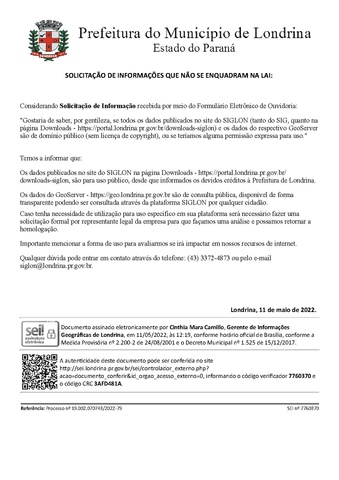
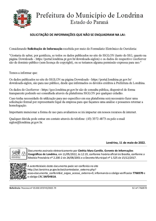
Considerando Solicitação de Informação recebida por meio do Formulário Eletrônico de Ouvidoria:
"Gostaria de saber, por gentileza, se todos os dados publicados no site do SIGLON (tanto do SIG, quanto na página Downloads - https://portal.londrina.pr.gov.br/downloads-siglon) e os dados do respectivo GeoServer são de domínio público (sem licença de copyright), ou se teríamos alguma permissão expressa para uso."
Temos a informar que:
Os dados publicados no site do SIGLON na página Downloads - https://portal.londrina.pr.gov.br/downloads-siglon, são para uso público, desde que informados os devidos créditos à Prefeitura de Londrina.
Os dados do GeoServer - https://geo.londrina.pr.gov.br são de consulta pública, disponível de forma transparente podendo ser consultada através da plataforma SIGLON por qualquer cidadão.
Caso tenha necessidade de utilização para uso específico em sua plataforma será necessário fazer uma solicitação formal por representante legal da empresa para que façamos uma análise e possamos retornar a homologação.
Importante mencionar a forma de uso para avaliarmos se irá impactar em nossos recursos de internet.
Qualquer dúvida pode entrar em contato através do telefone: (43) 3372-4873 ou pelo e-mail siglon@londrina.pr.gov.br.
Resposta
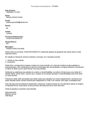
Prezada Cinthia, boa tarde!
Dando retorno ao processo 19.002.070743/2022-79, inicialmente gostaria de agradecer pelo rápido retorno e pela resposta positiva.
Em relação ao Geoserver, teríamos interesse, a princípio, em 2 camadas somente:
1 - ortofoto (a mais recente)
2 - arruamento
Desta forma, conseguiríamos mapear a cidade com maior precisão, por conta das ortofotos de alta qualidade (e posicionamento), como manteríamos a base de nomenclatura das vias atualizada e corrigida (utilizamos normalmente os dados do IBGE, que às vezes não tem uma boa precisão).
Verificando as estatísticas das edições de Londrina no OpenStreetMap, nos últimos 30 dias houve uma média de 3 edições diárias. Sendo assim, suponho que o impacto do uso dessas camadas no OpenStreetMap seria muito baixo no vosso servidor.
Poderíamos então obter autorização para utilizar essas duas camadas nos nossos mapeamentos? Lembrando que essas camadas seriam visíveis somente para mapeamento no OSM, e em nenhum outro lugar ou finalidade mais.
Caso não seja possível utilizarmos diretamente o Geoserver, podemos pensar em uma alternativa (baixar as imagens e hospedarmos por conta própria, ainda que talvez não seja possível do nosso lado isso).
Desde já agradeço novamente vossa atenção!
Atenciosamente,
Matheus Gomes
OSM Brasil
Resposta
Conforme processo relacionado 19.002.070743/2022-79, o solicitante não apresentou documentação que comprova a relação com a empresa OpenStreetMap.
As informações solicitadas:
1 - ortofoto (a mais recente) - A INFRAERO nos forneceu a imagem para ser disponibilizada para consulta pública em nosso domínio apenas. Não sendo possível liberar os arquivos para outra instituição.
2 - arruamento - é possível enviar o arquivo em shapefile com as informações estáticas, basta clicar no link abaixo:
Atenciosamente,
Gerência de Sistema de Informações Geográficas de Londrina
Licensing
- This media file was uploaded by author of the work and its copyright holder.
![]()
![]()
The person who associated a work with this deed has dedicated the work to the public domain by waiving all of his or her rights to the work worldwide under copyright law, including all related and neighboring rights, to the extent allowed by law. You can copy, modify, distribute and perform the work, even for commercial purposes, all without asking permission.
File history
Click on a date/time to view the file as it appeared at that time.
| Date/Time | Thumbnail | Dimensions | User | Comment | |
|---|---|---|---|---|---|
| current | 16:56, 23 September 2022 |  | 1,237 × 1,752, 3 pages (412 KB) | Matheusgomesms (talk | contribs) | {{Information | description=Capture of the e-mail sent by SIGLON (GIS of Londrina), where the use of their data is authorized on OpenStreetMap. | date=2022-05-30 | source=Own | author={{User|matheusgomesms|wiki=|noedits=1|m=n}} }} |
You cannot overwrite this file.
File usage
There are no pages that use this file.