File:Canoe route lkn.png
Jump to navigation
Jump to search

Size of this preview: 515 × 599 pixels. Other resolutions: 206 × 240 pixels | 413 × 480 pixels | 705 × 820 pixels.
Original file (705 × 820 pixels, file size: 1.67 MB, MIME type: image/png)
Summary
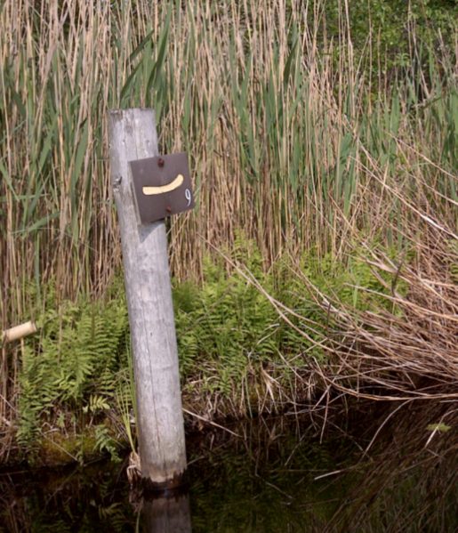
Numbered signpost (lpn_ref=9) along a local canoeing/kayaking route (network=lpn)
Note: this image was made as an illustration in the discussion how to tag differnt network-types for route=canoe. During the discussion the wording was changed from lkn (k for kayak) to the more general lpn (p for paddling, since lcn is already used for cycling networks and kayak is a specific subtype within the term canoe in OSM)
Licensing
![]()
I, the creator of this work, hereby release it into the public domain. This applies worldwide.
In case this is not legally possible, I grant anyone the right to use this work for any purpose, without any conditions, unless such conditions are required by law.
Notice to creator or uploader: Please consider using {{CC0-self}} instead for your work.
"Releasing work to public domain" has some issues, as it is not well defined in some jurisdictions and/or it is not actually possible to "release to public domain". Using CC0 license achieves the intended effect while avoiding such problems and is well suited for media files.
File history
Click on a date/time to view the file as it appeared at that time.
| Date/Time | Thumbnail | Dimensions | User | Comment | |
|---|---|---|---|---|---|
| current | 23:44, 2 July 2018 | | 705 × 820 (1.67 MB) | Multimodaal (talk | contribs) |
You cannot overwrite this file.
File usage
The following 65 pages use this file:
- Ar:Map Features
- Ast:Map Features
- Az:Map Features
- Bg:Map Features
- Ca:Elements cartogràfics
- Cs:Key:route
- Cs:Map Features
- Cs:Relation:route
- Da:Map Features
- El:Map Features
- Eo:Map Features
- Fa:Map Features
- Fi:Kartan ominaisuudet
- Gl:Key:route
- He:Map Features
- Hu:Map Features
- Ko:Relation:route
- Lv:Map Features
- Map features
- Ne:Map Features
- Oc:Elements cartografics
- Pl:Key:route
- Pl:Relation:route
- Pt:Key:route
- Pt:Map Features2
- Relation:route
- Ro-md:Map Features
- Ro:Map Features
- Sr:Map Features
- Sv:Map Features
- Uk:Relation:route
- Zh-hans:Map Features
- Zh-hans:Relation:route
- User:Chillly/Simple Map Features
- User:H4ck3rm1k3/OSMKeys
- Template:Ar:Map Features:route
- Template:Az:Map Features:route
- Template:Ca:Map Features:route
- Template:Cs:Map Features:route
- Template:DE:Map Features:route
- Template:Da:Map Features:route
- Template:Et:Map Features:routes
- Template:FR:Map Features:route
- Template:Fi:Map Features:route
- Template:Generic:ES:Map Features:route
- Template:Gl:Map Features:route
- Template:Hu:Map Features:route
- Template:IT:Map Features:route
- Template:JA:Map Features:route
- Template:Ko:Map Features:route
- Template:Map Features:route
- Template:NL:Map Features:route
- Template:Oc:Map Features:route
- Template:Pl:Map Features:route
- Template:Pt:Map Features:route
- Template:Uk:Map Features:route
- Template:Zh-hans:Map Features:route
- Template:Zh-hant:Map Features:route
- DE:Relation:route
- FR:Éléments cartographiques
- IT:Key:route
- IT:Map Features
- NL:Kaartelementen
- JA:Map Features
- JA:Relation:route