File:MapSwipe results to tasking manager.png
Jump to navigation
Jump to search


No higher resolution available.
MapSwipe_results_to_tasking_manager.png (517 × 254 pixels, file size: 95 KB, MIME type: image/png)
Summary
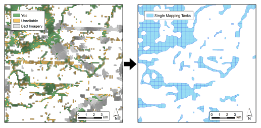
Illustrations by DisasterMappers Heidleberg, from the blog Integrating MapSwipe and HOT Tasking Manager – First Task Online!
DisasterMappers Heidleberg created the image (The right had side one is certainly in QGIS, maybe the left too). Harry added the arrow
This is a Featured image, which means that it has been identified as one of the best examples of OpenStreetMap mapping, or that it provides a useful illustration of the OpenStreetMap project. If you know another image of similar quality, you can nominate it on Featured image proposals.
Front-page image for week 48 of 2016 (28 Nov. – 4 Dec.).
- Image descriptions
- asturianu : Munches persones clasificaron imáxenes con una nueva app de micro-xeres simple enforma, MapSwipe. Esta imaxe ilustra un procesu desendolcáu por DisasterMappers Heidelberg pa coyer los resultaos de MapSwipe (izquierda) y encadarmar un proyeutu del Task Manager pa facer un mapa d'asentamientos (drecha).
- English : Many people have been classifying imagery in a new super-simple micro-tasking app called MapSwipe. This image illustrates a process developed by DisasterMappers Heidelberg for taking MapSwipe results (left) and setting up a Task Manager project to map the settlements (right).
- italiano : Molte persone hanno classificato immagini in una nuova app di micro-tasking estremamente semplice, MapSwipe. Questa immagine illustra un processo sviluppato da DisasterMappers Heidelberg per prendere i risultati di MapSwipe (sinistra) e impostare un progetto del Task Manager per mappare gli insediamenti (destra).
- українська : Супер-простий додаток Мап-свайп дав сотням людей можливість взяти участь у класифікації супутниковых знімків. На ілюстрації показано, як результат цієї роботи (зліва) перетворюється на набір завдань з картирування поселень (зправа). Алгоритм розробили волонтери з співтовариства Дизастерс-маперс у Гейдельбергу.
- 中文(简体) : 很多民众透过超级简单的微任务 app MapSwipe 来帮忙影像分类。这张图片显示由海德堡灾难绘图者制订的流程,来处理MapSwipe 的结果(左),以及依据上面得到的结果来设任务管理员专案,绘制发现的聚落(右)。
- 中文(繁體) : 很多民眾透過超級簡單的微任務 app MapSwipe 來幫忙影像分類。這張圖片顯示由海德堡災難繪圖者製訂的流程,來處理 MapSwipe 的結果(左),以及依據上面得到的結果來設任務管理員專案,繪製發現的聚落(右)。
- فارسی : افراد زیادی توسط نرمافزار کوچکی به نام MapSwipe تصاویر هوایی را به تکههای بسیار ساده و کوچک وظایف دسته بندی میکنند. این تصویر فرآیند ایجاد شده توسط نقشهکشهای زمان حادثه هایدلبرگ را نشان میدهد که طی آن نتیجه MapSwipe را (سمت چپ) دریافت کرده و یک نقشه تقسیم وظایف ایجاد میکنند تا نقشه مناطق مسکونی کشیده شود (سمت راست).
Licensing
![]()
![]()
![]()
This work is licensed under the Creative Commons Attribution-ShareAlike 2.0 License.
Attribution not specified as a parameter! THIS LICENSE ALWAYS REQUIRES ATTRIBUTION! Use {{CC-BY-SA-2.0|Attribution, typically name of author}} See Template:CC-BY-SA-2.0 for full description how this template should be used.
Note, there is
There is also
Attribution not specified as a parameter! THIS LICENSE ALWAYS REQUIRES ATTRIBUTION! Use {{CC-BY-SA-2.0|Attribution, typically name of author}} See Template:CC-BY-SA-2.0 for full description how this template should be used.
Note, there is
{{CC-BY-SA-2.0 OpenStreetMap}} for files based on old OSM map data, before the license change made on 2012-09-12.There is also
{{OSM Carto screenshot||old_license}} for files based on old OSM map data, before the license change made on 2012-09-12, created using OSM Carto map style.
Published here CCBYSA2.0 with permission
File history
Click on a date/time to view the file as it appeared at that time.
| Date/Time | Thumbnail | Dimensions | User | Comment | |
|---|---|---|---|---|---|
| current | 12:09, 21 November 2016 | | 517 × 254 (95 KB) | Harry Wood (talk | contribs) | Illustrations by DisasterMappers Heidleberg, from the blog https://disastermappers.wordpress.com/2016/11/16/integrating-mapswipe-and-hot-tasking-manager-first-task-online/ Integrating MapSwipe and HOT Tasking Manager – First Task Online!] |
You cannot overwrite this file.
File usage
The following 14 pages use this file:
- Featured images/Oct-Dec 2016
- MapSwipe
- Pt:MapSwipe
- Uk:Featured images/Oct-Dec 2016
- Zh-hans:Featured images/Oct-Dec 2016
- Zh-hant:Featured images/Oct-Dec 2016
- Template:Featured image d4
- Template:Iotw image/2016-48
- DE:Featured images/Oct-Dec 2016
- FR:Featured images/Oct-Dec 2016
- ES:Imágenes destacadas/Oct-Dic 2016
- IT:Featured images/Oct-Dec 2016
- RU:Featured images/Oct-Dec 2016
- JA:Featured images/Oct-Dec 2016