Zh-hant:Featured images/Oct-Dec 2016
Jump to navigation
Jump to search


這是特色圖片,展現開放街圖畫地圖範例,以及最能代表開放街圖的專案。
如果你知道其他有類似品質的圖片,你可以在特色圖片提名處(en)提名。
| ← 從2015年10月到12月 | ← 從2016年7月到9月 | 從2017年1月到3月 → | 從2017年10月到12月 → |
特色圖片庫、從2016年10月到12月
2016年、第40週
2016年、第41週

2016年、第42週
2016年、第43週
2016年、第44週
2016年、第45週

2016年、第46週

2016年、第47週
2016年、第48週

2016年、第49週
2016年、第50週

2016年、第51週
2016年、第52週
細節和字幕
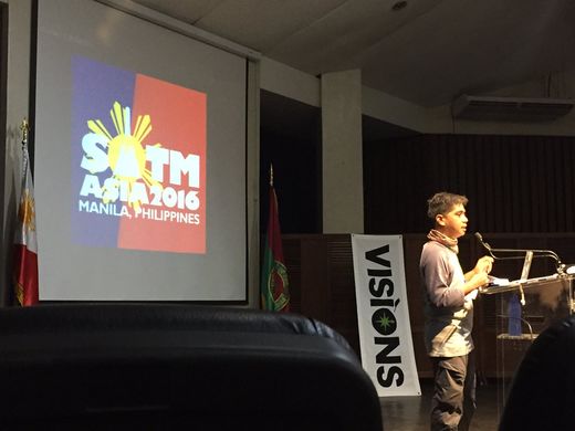
第40週(從2016年10月3日星期一到2016年10月9日星期日) [Edit]

- English : Opening session at State of the Map Asia 2016 in Manila, Philippines last weekend.
- 中文(繁體) : 上週末在菲律賓馬尼拉舉行的State of the Map Asia 2016開幕式。
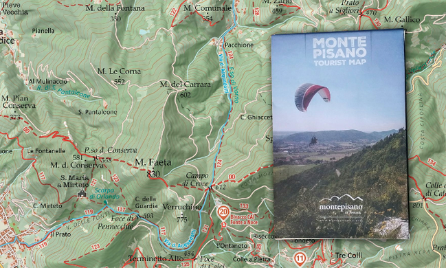
第41週(從2016年10月10日星期一到2016年10月16日星期日) [Edit]

- English : Marco Barbieri presented his cartographic work at OSMit last year, producing these attractive web maps (webmapp.it) and printable tourist maps of Monte Pisano, as well as organising mapping parties in this part of Italy.
- 中文(繁體) : Marco Barbieri 在去年OSMit上發表他的地圖設計工作,創造這幾個吸引人的網路地圖(webmapp.it),還有推出可列印的Monte Pisano旅遊地圖,當然還有在義大利這塊地方辦圖客趴。
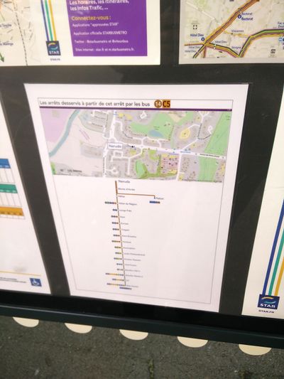
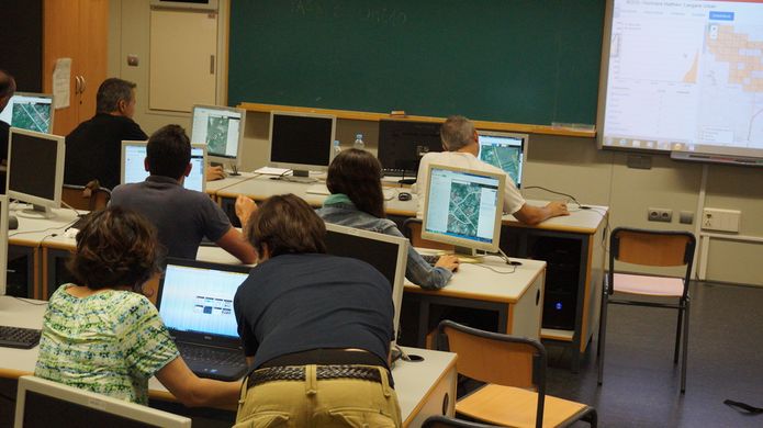
第42週(從2016年10月17日星期一到2016年10月23日星期日) [Edit]

- English : The public transport service STAR in Rennes Metropole, France, uses OpenStreetMap on their information boards.
- 中文(繁體) : 法國雷恩一帶當地的"STAR"巴士服務,資訊立版使用開放街圖。
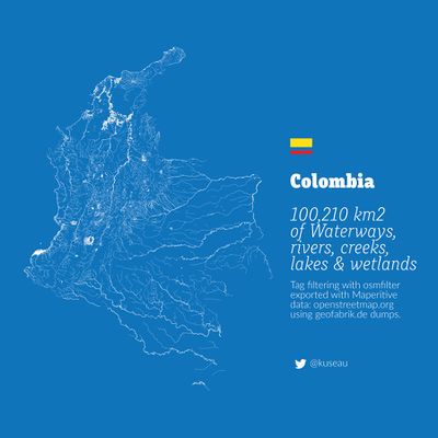
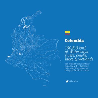
第43週(從2016年10月24日星期一到2016年10月30日星期日) [Edit]

- English : A beautiful image showing all the rivers, lakes, creeks and wetlands of Colombia by Omar Pineda.
- 中文(繁體) : 這張顯示所有哥倫比亞的河川、湖泊、小溪和溼地的地圖,由Omar Pineda製作。
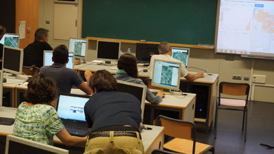
第44週(從2016年10月31日星期一到2016年11月6日星期日) [Edit]

- English : This mapathon in Valencia, Spain, was one of many worldwide disaster response mapping events taking place in response to Hurricane Matthew.
- 中文(繁體) : 這次在西班牙瓦倫西亞舉行的mapathon,是眾多在世界各地為了颶風馬修,舉行的災難救護畫地圖活動。
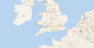
第45週(從2016年11月7日星期一到2016年11月13日星期日) [Edit]

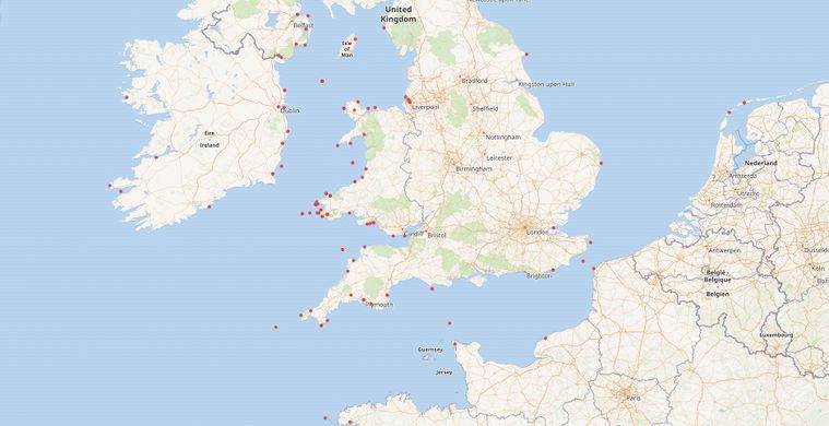
- English : The WikiData project has an eclectic mix of linked datasets and provides a querying interface which can yield a map. This example by Jason Evans shows positions of 19th century Aberystwyth ships wrecked at sea, using data from National Library of Wales and the Ceredigion Archives.
- 中文(繁體) : WikiData專案具有混合組合的連接資料集,並且提供可以產生地圖的查詢界面。Jason Evans的這個例子,使用威爾士國家圖書館和錫爾迪金檔案庫資料,顯示19世紀阿伯里斯特威斯船在海上失事的位置。
第46週(從2016年11月14日星期一到2016年11月20日星期日) [Edit]

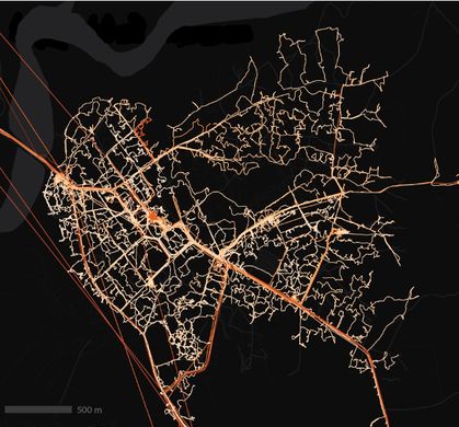
- English : Interchange Choreography by Nicholas Rougeux, is an artistic exploration of major road intersections "Applying colors to roads and using connecting roads to blend those colors".
- 中文(繁體) : 由Nicholas Rougeux製作的交換編舞,是用藝術家的方式探索主要道路交叉,「將道路上色,而且連接道路時會混色」。
第47週(從2016年11月21日星期一到2016年11月27日星期日) [Edit]

- English : Take open data from OpenStreetMap and have it turned into a stylish and unique pendant on meshu.io!
- 中文(繁體) : 拿開放街圖的開放資料,在meshu.io訂製有造型而且特別的吊墜!
第48週(從2016年11月28日星期一到2016年12月4日星期日) [Edit]

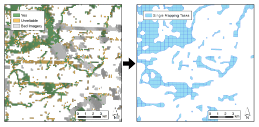
- English : Many people have been classifying imagery in a new super-simple micro-tasking app called MapSwipe. This image illustrates a process developed by DisasterMappers Heidelberg for taking MapSwipe results (left) and setting up a Task Manager project to map the settlements (right).
- 中文(繁體) : 很多民眾透過超級簡單的微任務 app MapSwipe 來幫忙影像分類。這張圖片顯示由海德堡災難繪圖者製訂的流程,來處理 MapSwipe 的結果(左),以及依據上面得到的結果來設任務管理員專案,繪製發現的聚落(右)。
第49週(從2016年12月5日星期一到2016年12月11日星期日) [Edit]

- English : State of the Map Latam 2016, the conference for Latin America, took place last week in São Paulo.
- 中文(繁體) : State of the Map Latam 2016是拉丁美洲的社群大會,上週在聖保羅舉行。
第50週(從2016年12月12日星期一到2016年12月18日星期日) [Edit]

- English : Local volunteers trained by the American Red Cross have mapped 7,000 villages in the border regions of Liberia, Guinea, and Sierra Leone. A total of 70,000 kilometres of roads and paths, including this example, Forécariah in Guinea.
- 中文(繁體) : 由紅十字會訓練的在地志工繪製賴比瑞亞、幾內亞、獅子山邊境一帶 7,000 個村莊,並且繪製總長超過 70,000 公里的道路和路徑,包括圖中的例子,幾內亞的Forécariah。
第51週(從2016年12月19日星期一到2016年12月25日星期日) [Edit]

- English : These stripped down maps elegantly characterise world cities by highlighting the shape of water features. They were created by Alex Szabo-Haslam and recently featured in a guardian cities quiz. How many do you recognise?
- 中文(繁體) : 這些截取的地圖藉由強調水體形狀的圖徵,優雅的呈現世界各地的城市。Alex Szabo-Haslam創造這些圖,並在a 衛報的城市小測驗出現。你認得幾個城市呢?
第52週(從2016年12月26日星期一到2017年1月1日星期日) [Edit]

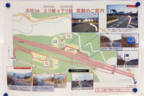
- English : A poster about how to make a U-turn at Hamamatsu highway service area, made by the Shizuoka prefecture, Japan.
- 中文(繁體) : 由日本靜岡縣政府製作的告示牌,告知要如何在濱松高速公路休息區迴轉。