Hurricane Sandy

Hurricane Sandy was a category 1 hurricane which hit the Caribbean before strengthening and hitting the North Eastern U.S. with devastating effects on October 29, 2012. wikipedia:Hurricane Sandy has more.
OpenStreetMap in use
Openstreetmap offers free and open maps, available as raw data, and as stylishly rendered map images by a number of 3rd parties. This makes for an exciting geo-data platform for developers to create powerful map visualisations presenting information related to events such as this. There are many examples of OpenStreetMap in use. Here are a few:
- boston news - power outage map - uses OSM
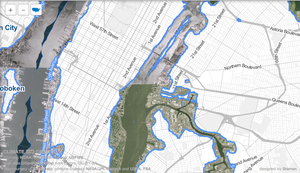
- map of flood prone evacuation priorities in New York by NYC GIS department - uses OSM
- Surging Seas map simulating sea level rises - Clever interface using OSM, although not created in relation to the hurricane (but rather climate change)
- The Ushahidi platform is deployed, in fact several times over, several on crowdmap.com for example. Some of these are set to use OpenStreetMap as the base map e.g. Hurricane Sandy in the DMV (though this has no reports)
Mapping effected areas
OpenStreetMap is openly editable, so at a local level people can provide crucial map updates and supply details of local facilities pertinent to disaster response, infrastructure and recovery efforts. Although we don't deal with very temporary situational data, we aim to create a rich and detailed canvas upon which this information can be overlaid.
In general any kind of enrichment of our map data will help towards this aim. We are mostly not coordinating any more specific mapping targets at this time, but armchair mappers might focus their efforts as follows:
- Be aware of some Armchair mapping cautions. Avoid areas which already have attention from local mappers (so not Manhattan Island)
- The worst effected areas are in the north east of the U.S. along coasts.
- Hospitals can be mapped in more detail from bing imagery. See the Hospital docs for details
- Likewise schools are used as evacuation facilities and are good things to add to the map in more detail.
- Some inland waterways data is imported from NHD and requires extensive fixup.
- And of course, some areas of the U.S require extensive TIGER fixup. Finding these areas is always a good way to focus armchair mapping efforts.
You may find more mapping coordination information drilling down from U.S., to more local wiki pages. See also http://openstreetmap.us and discuss mapping on the local or community-wide Contact channels.