IT:Tag:landuse=greenhouse_horticulture
Jump to navigation
Jump to search
| Descrizione |
|---|
| Terreno usato per coltivare piante in serre. |
| Rappresentazione in OSM Carto |

|
| Gruppo: landuse |
| Applicabile agli elementi |
| Combinazioni utili |
|
| Stato: approvato |
| Strumenti |
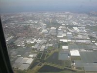
Terreno usato per coltivare piante in serre. Gli edifici, i serbatoi d'acqua e le aree aperte attorno alle serre utilizzate per il funzionamento delle serre stesse dovrebbero essere considerati parte di tale uso del territorio.
Per etichettare singole serre, usare building=greenhouse.
Come mappare
Disegna il perimetro dell'area ![]() e aggiungere landuse=greenhouse_horticulture.
e aggiungere landuse=greenhouse_horticulture.
Esempio
| Picture | OSM Carto |
|---|---|

|
Vedere anche
- building=greenhouse per singole serre
- shop=garden_centre
- shop=florist
- Proposed features/greenhouse horticulture, proposta originale
Possibili sinonimi
| ||||||||||||||||||||||||||||||||

