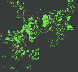
Import/City of Flagstaff, Arizona Buildings and Addresses
This is a completed import of municipal building and address data for the City of Flagstaff, Arizona. This effort built on some data preparation and import steps previously used to successfully import buildings and addresses for the City of Redlands, California.
Goals
Import Flagstaff building footprints and address point data sets to complete the coverage of building footprints and addresses for the City, using authoritative data from the City that was digitized from aerial imagery. OSM currently has limited coverage for the 27,000+ buildings and 37,000+ addresses in the City. This import will greatly expand and enhance the coverage of buildings and addresses for the city, while retaining the buildings already added to OSM.
Schedule
Data preparation and import work to be performed in February-March 2020, with the import performed incrementally over a period of 1-2 weeks.
Results
Through the import, there were 22,100 buildings added for the City of Flagstaff and local surrounding area. Of these buildings, approximately 57% included address tags (i.e. house number, city, and postcode). Though the second phase of the import, there were 21,660 address points added for the City of Flagstaff.
Source
Data was provided by the City of Flagstaff GIS Team, and to be available via their Open Data Portal.
Latest Building Footprints and Address Points, as of February 2020, have been processed and published as live feature layers and layer packages for download.
- Flagstaff Buildings: layer contains 27,123 buildings, of which 22,140 do not overlap OSM building data (initial analysis)
- Live Feature Layer with Popup: https://openstreetmap.maps.arcgis.com/home/item.html?id=2117f9d46f914fb29aa9c9ac584249e8
- Layer Package to Download: https://openstreetmap.maps.arcgis.com/home/item.html?id=09d9001a1c4d4c3994e443e81c6fc062
- Flagstaff Addresses: layer contains 37,175 addresses, of which 21,789 do not duplicate OSM data (including new buildings above)
- Live Feature Layer with Popup: https://openstreetmap.maps.arcgis.com/home/item.html?id=d3661b8ae03947899efcf7d1b1e848d3
- Layer Package to Download: https://openstreetmap.maps.arcgis.com/home/item.html?id=63cefa17c15d4454a160bf36a1fdbf72
OSM ODbL Compliance: Yes, explicit permission to integrate data with OpenStreetMap given by GIS Team for the City.
Data Preparation
After initial review of the data, the plan is to separately publish building footprints and address points. This is primarily because most address points are placed toward the front of property and not on the buildings. For apartments and other building complexes with multiple addresses, the address points are typically placed on the buildings with different points for each unit. In both cases, publishing the address points separately from the building footprints is preferable.
Buildings
For the building footprints, the features will be assigned tags based on values in the City data source attributes as summarized below. The Building Subuse attribute values (e.g. Apartment, College, Garage, Restaurant, etc.) will be mapped to the appropriate Building tag, to be finalized during data preparation.
| Source Attribute | OSM Tag |
|---|---|
| Building Subuse | building=* |
| Building Name | name=* |
Address Points
For the address points, the features will be assigned tags as summarized below.
| Source Attribute | OSM Tag |
|---|---|
| Address Number (Calc) | addr:housenumber=* |
| Street (Calc) | addr:street=* |
| City (Calc) | addr:city=* |
| State (Calc) | addr:state=* |
| Zipcode | addr:postcode=* |
| Suite | addr:unit=* |
Calc: some attributes will need to be calculated based on existing attributes in the City data source, or other data source.
- House number to be pre-calculated in GIS to equal AddressNumber + AddressNumberSuffix (e.g. 1/2)
- Street to be pre-calculated in GIS to equal Prefix Direction + Streetname + Suffix Type + Suffix Direction.
- Streetname to be converted from All Caps to Title Case (e.g. RIORDAN RANCH to Riordan Ranch).
- Suffix Type to be converted from abbreviation to full word (e.g. LN to Lane, RD to Road, ST to Street).
- City to be pre-calculated based on Census Populated Places data (e.g. Flagstaff).
- State to be pre-calculated based on Census State data (e.g. AZ).
Data Import
Existing building features in OSM will not be replaced. The plan is to perform the import in two steps. In the first step, new buildings that do not intersect existing buildings or other OSM data (e.g. water, roads) will be added. In the second step, new address points that are not in close proximity to existing address points (e.g. amenity features with addresses) will be added, to avoid duplication of the same address in multiple features.
Import Type
This import will be done in sections (block groups) using ArcGIS Editor for OSM. Import will be tested on Development server first.
Import Accounts
New dedicated import account(s) to be created and used for import, including the following.
 dkensok_flagstaff_import (on osm, edits, contrib, heatmap, chngset com.)
 jshimota_flagstaff_import (on osm, edits, contrib, heatmap, chngset com.)
Changeset Tags
Will set source = City of Flagstaff

