Kentucky
| V・T・E |
| latitude: 38.2, longitude: -84.88 |
| Browse map of Kentucky 38°12′00.00″ N, 84°52′48.00″ W |
| Edit map |
|
External links:
|
| Use this template for your locality |
Kentucky is a state in the United States at latitude 38°12′00.00″ North, longitude 84°52′48.00″ West.

Cities and regions
Resources
The most popular OSM editors offer a variety of aerial and satellite imagery layers to trace against. Maxar Premium and Maxar Standard are the most up-to-date. Mapbox has the highest resolution (clearest) in urban areas like Northern Kentucky, while Esri Clarity offers slightly better resolution than Mapbox in rural areas. The USGS Topographic Maps layer is especially useful for naming waterways and realigning imported boundaries.
In addition to these standard layers, two KyFromAbove layers are also available in many counties. These layers are the best aligned and the images were taken at a time of year when the leaves were off the trees, making it easier to spot ground-level details. The KyFromAbove 2019 and 2020 6-inch layers are also the most up-to-date and highest-resolution layer available for Eastern and Northern Kentucky and the Bluegrass Region.
When mapping a tall building or a road in a hilly area, choose a well-aligned, high-resolution layer to draw the building footprint with minimal skew or offset, then switch to the most current layer to look for any additions or demolitions that may have taken place recently. When mapping in a wooded area, choose a leaf-off layer so you can easily see through tree cover. When mapping bodies of water, choose a leaf-on layer, which is more likely to show the low-water mark.
Tagging suggestions
Numbered routes
| Marker | ||
|---|---|---|
 |
ref=I 64 | network=US:I ref=64 |
 |
ref=US 25 | network=US:US ref=25 |
 |
ref=KY 3487 | network=US:KY ref=3487 |
 |
ref=AA | network=US:KY ref=AA |
 |
noref=yes unsigned_ref=AU 9005 |
network=US:KY:Parkway name=Audubon Parkway unsigned_ref=9005 |
Speed limits
Speed limits in OSM interpreted as kilometers per hour by default, so speed limits in the U.S. must be explicitly labeled as miles per hour: maxspeed=25 mph. Remember to use a space and lowercase the "mph" abbreviation.
Weight restrictions

 Kentucky:
maxweight=25 st
maxweight:hgv:conditional=25 st @ (axles=2); 28 st @ (axles=3); 34 st @ (axles=4 or axles=5); 35 st @ (axles=6); 38 st @ (axles>=7)
maxweight:hgv_articulated=44 st
(specify unit as short tons)

Highway entrances and exits
Exit numbers are tagged in two places: on highway=motorway_junction nodes using the ref=* tag and on highway=motorway_link or highway=trunk_link ways using the junction:ref=* tag.
Route markers on entrance and exit guide signs are tagged on highway=motorway_link or highway=trunk_link ways using the destination:ref=* and destination:ref:to=* tags. The tag values should match the ref=* tags of the ways that the guide signs refer to, as listed in "Numbered routes". Note that Kentucky state routes have the prefix KY, not SR, while Kentucky parkways have no signposted numbers.
Road names and place names on entrance and exit guide signs are tagged on highway=motorway_link or highway=trunk_link ways using the destination=* tag. Do not use the deprecated exit_to=* tag on highway=motorway_junction nodes. Road names should match the name=* tags on the roadways that the guide signs refer to.
A supplemental road name is a road name that appears in smaller type on a guide sign, usually in all caps beside a route marker. When mapping highway ramps based on a guide sign, place supplemental road names in the destination:street=* tag but other road names in the destination=* tag. Parkway names also go in the destination:street=* tag.

junction:ref=182
destination:ref=KY 1017
destination=Turfway Road
junction:ref=3
destination:ref=KY 1892
destination:street=Grand Avenue
destination=Fort Thomas;Newport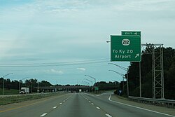
junction:ref=4
destination:ref=KY 212
destination:ref:to=KY 20
destination=Airport
junction:ref=77
destination:ref=KY 9;AA
destination=Wilder;Maysville
junction:ref=94
destination:ref=KY 1958 South;KY 627 Truck South
destination=Van Meter Road;Winchester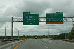
Left:
junction:ref=1B
destination:ref=I 65 South
destination:street:to=Western Kentucky Parkway
destination=Nashville;Paducah
Right:
junction:ref=1A
destination:ref=I 65 North
destination=Elizabethtown;Louisville
Right:
junction:ref=137B
destination:ref=I 65 North
destination:street:to=Bluegrass Parkway
destination=Lexington;Louisville
maxspeed:advisory=20 mph
destination:street=William H. Natcher Parkway North
destination:ref:to=I 65
.jpg)
.jpg)
.jpg)
.jpg)
.jpg)
.jpg)
.jpg)
.jpg)
Geographical disputes
See Ohio River for how OpenStreetMap deals with the historic border dispute along that river.
OSM in the wild
- The Kentucky Transportation Cabinet's GoKY traffic portal plots Waze traffic data against an OSM basemap.
See also Cincinnati, Ohio#OSM in the wild
External links
- University of Louisville GIS Department
- Kentucky Cities – Kentucky Secretary of State database of city filings, including city ordinances with boundary definitions