Mapping of risk areas in Maricá City, Rio de Janeiro, Brazil
Mapping of risk areas in Maricá City, Rio de Janeiro, Brazil
Research in progress (March, 2023 - )
Keep contact
Dra. Raquel Dezidério Souto (IVIDES.org e GeoCart-UFRJ)
Prof. Dr. Manoel do Couto Fernandes (GeoCart-UFRJ)
Dynamic Web maps
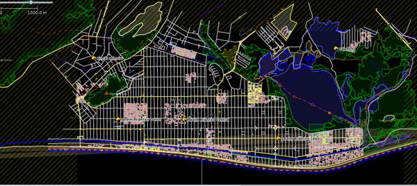
uMap - with the points of interest (POI) and another features that are interesting to this research, included in layers with Overpass recursively queries integrated in the uMap.
Dynamic Web Map at IVIDES.org - with the features validated by the mappers and showed in a thematic style.
Initial Area of Interest (AOI)
The AOI initially considered (pilot project) was subdivided into seven projects, in order to make the mapathons (marathons of mapping) viable and to facilitate the validations. Each of these areas corresponds to a neighborhood in the city of Maricá. The mapping projects are available in the TeachOSM Tasking Manager (#1529 #1535 #1536 #1537 #1538 #1539 #1542), easily searchable by the name of the city: "Maricá": https://tasks.teachosm.org/explore?text=Maric%C3%A1
Area #1 - Jardim Atlântico
Area #2 - Itaocara
Area #3 - Cajueiros
Area #4 - Mumbuca
Area #5 - Centro
Area #6 - Bananal
Area #7 - Jaconé
Motivation
The city of Maricá (State of Rio de Janeiro, Brazil) presents increasing occurrences of flood events, mass movements and coastal erosion, affecting buildings and highways present in the city center and in other locations, causing disruption to the population and lost of lifes. This project is being coordinated by IVIDES.org, in a collaboration with the mappers of the YouthMappers UFRJ Chapter, with occasional assistance of other mappers from Brazil and other countries, like Angola and Mozambique (Africa).
The data and information collected in this mapping can contribute for the disaster risk reduction (DRR) and has the initial specific objective of mapping: a) buildings, b) highways, c) points of alert (POA) and points of interest (POI, amenities), which are important in the preventing and emergency activities; d) warning and emergency sirens; e) hydrological and geological monitoring stations; and f) barriers.
Mapping phases
1. Acquiring data
Data is being prospected from the following sources: OpenStreetMap, Municipality of Maricá (related municipal departments), The Brazilian Institute of Geography and Statistics (2022 Demographic Census), Military Firefighters Corps of the State of Rio de Janeiro and other official sources; and data from researchers who has interest in the same AOI.
2. Data validations
2.1 - Checking the geometry of features (e.g., whether buildings are not orthogonalized and other types of errors, such as overlapping highways and buildings) - with the Java OpenStreetMap Editor (JOSM);
2.2 - Data duplicity identification and data integrity check - with respect to the incomplete or erroneous data, corrected according to the sources of data - with JOSM, iD, Osmium, OSMCha, Osmose e OSM Inspector; and
2.3 - Checking the adequacy of labels - with Osmium, OSMCha, Osmose e OSM Inspector.
3. Making data available with ODbL compatible licenses
Since the data is being mapped, as far as possible, with the OpenStreetMap , it is necessary that data license are compatible with the ODbL license. Data from the Brazilian producers of official statistics (e.g. IBGE) are public and we are investigating about the availability of other kind of data (from the researchers and research institutions) with ODbL compatible licenses.
4. Making information available on a virtual and collaborative platform
The collaborative mapping platform is being developed by the IVIDES.org Institute, in the person of Dr. Raquel Dezidério Souto, in dialogue with the groups of researchers and government actors from institutions directly linked to civil protection and defense in the municipality of Maricá.
The collaborative mapping platform is available (still in its initial aspect), with public access, following this link: https://ivides.org/infomarica.
Links of interest
https://tasks.teachosm.org/explore?text=Maric%C3%A1
https://umap.openstreetmap.fr/pt-br/map/infraestrutura-para-rrd_1013950#12/-22.9233/-42.8432
