Pic4Carto
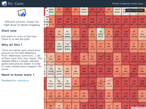
Pic4Carto (Framagit) is web based map tool to help find open licensed street level photos. This is specifically intended to aid contribution to OpenStreetMap, but can also be used in other contexts, for example educational purposes. It is designed to be efficient as possible.
Rationale
Since a few years, we have more and more street-level pictures available around the web. Some of them are under an open license, and can be used for editing OpenStreetMap. And pictures are an interesting source: we can see everything visible in the street at a very precise level. However, those pictures aren't as used as they might be. This can be explained by the multitude of providers, every of them having its own website, with its own user interface, and not always efficient. So for mappers, it can be discouraging to use pictures for mapping. That's why Pic4Carto was designed: to let mappers (and everyone) access these pictures, from all sources, grouped by geolocation, in an efficient way. That way, it's easy to browse every available picture and add to OSM what we can see on them: fire hydrants, advertisements, urban equipments... So we can use the full potential of these pictures.
Functionalities
- Browse available pictures in a given area. Available pictures providers are: Mapillary, Flickr, OpenStreetCam and Wikimedia Commons. Pictures are shown from most recent to older ones (up to 6 months ago).
- Filter pictures by any user-defined time range.
- Edit OpenStreetMap using JOSM or iD with "Edit" buttons, loading in the editor the area shown in the picture.
- Shortcuts for efficiency: right/left arrows for next/previous picture, space bar for play/pause, and R key for rotating picture.
- Grid shown on main map can be exported to be used in other tools.
Usage examples
- Pic4Carto & Mapcraft - Exhaustive collaborative mapping on an area.
- Direct link in JOSM using Utilsplugin2:
Development
Developed by User:PanierAvide in ES6 (JavaScript). The source code is available on Framagit, under AGPL 3 license. Contributions and comments are welcome.
Pic4Carto.js
The core functionality of pictures retrieval from several sources is also available as a standalone JavaScript library named Pic4Carto.js. It can be integrated simply in web-mapping tools, allowing users contextualize their contribution, add street-level details and so on.
A simple tutorial is available here: Some pictures for your maps with Pic4Carto.js.
HTTP API (P4CaaS)
To make it even simpler to use, Pic4Carto is also available as a HTTP API named P4CaaS (Pic4Carto as a Service). Anyone can request this API to get pictures, the same way as it's done in Pic4Carto.js.
An open instance is kindly hosted on OpenStreetMap France servers: http://api-pic4carto.openstreetmap.fr (documentation).
See also
- Pic4Review - Easy editor for OSM using street-level pictures (thanks to Pic4Carto.js library)
- Photo mapping - Technique for editing OSM using pictures.
- Photo linking - Create links between OSM features and external pictures.

