RD Congo Kivu
The South and North-Kivu Provinces share a long border with Burundi, Rwanda and Uganda and have been the refuge of various rebel groups for more than ten years. There is presently more than 800,000 displaced people and 100,000 persons in camps. The recent fightings provoked important displacements of people. In early December 2012, the ICRC highlighted the worrying and complex humanitarian situation in this region. There is currently a relative lull in the areas that were hardest hit by the recent fighting, while at the same time other parts of Kivu communities suffer the effects of fighting and acts of extreme violence, which spare neither women nor children.
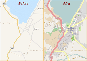
While insecurity and violence continues, the humanitarian organizations try to join refugees where they are and support them. Taking into account the number of displaced people, their needs for food, water and medical treatments and secure environment, plus the difficulty to locate and join them, this is a major operation. Detailed maps of these areas are needed by the humanitarian organizations.
The HOT Team presently coordinates efforts with humanitarian agencies and a GIS specialist on the ground in Kinshasa.
Coordination : Pierre Béland
Contact in RDC : Claire Halleux
For more long term mapping and OSM community coordination in Congo, see the WikiProject Congo-Kinshasa page and the associated talk page.
2012 Humanitarian Response
Pre-Activation 2012-11-20
For the Pre-Activation, the priority is to map areas around Lac Kivu along the RN2 road from Goma north of the lake to Bukavu, south of the lake for a distance of more then 130 km. Micro-tasks are defined where Bing High-Res Imagery is available. Hot Task Manager is used by the HOT coordinator to define these micro-tasks. Areas around Goma, Bweremana and Minova, were displaced people are reported, have been traced in priority.
Activation 2012-12-16
Given the very volatile situation in the Kivus and the large zone to cover, HOT changes the status of this intervention from Pre-Activation to Activation. We are still looking for aerial imagery for areas not covered to adequately respond to this humanitarian emergency.
The OSM Tasking Manager
The HOT Tasking Server is used to coordinate simultaneous work of various contributors. The mappers may select a micro-task and contribute mapping. Various tasks have been defined to map various areas around Lac Kivu.
Editors such as Potlatch2 or JOSM are used to edit the map for the selected micro-task.
| Current Tasks / Wikipedia Link | Comments |
|---|---|
| North-Kivu | |
| New imagery should be available soon | |
| South-Kivu | |
| Job 793 Missing Maps: Bukavu, Democratic Republic of Congo | Adding more details - buildings and smaller roads |
| Job 211 Minova and Sake areas | Cholera Epidemic |
| Job 140 RN2 Kalengera - Burhale | Major road access to North Kivu |
| Job 113 Kalemie | |
| Completed tasks | Comments |
| North-Kivu | |
| Job 102 Goma | |
| Job 110 Kamakombe | |
| Job 116 Nyiragongo Volcano | Displaced people |
| Job 117 Masisi ♦ Nyabiondo | Displaced people |
| Job 122 Ruthsuru ♦ Bwito | Displaced people |
| Job 129 Nyabiondo 2 | Displaced people |
| South-Kivu | |
| Job 108 Minova | Arrival of displaced people |
| Job 109 Bukavu-East | |
| Job 118 Uvira | Cholera epidemy High Priority |
| Job 125 Uvira ♦ RN5 Ruviza Uvira | Major road access to North Kivu |
| Job 126 Kabare ♦ RN5 Bukavu Katagota | Major road access to North Kivu |
| Job 137 Kalehe | Major road access to North Kivu |
Downloads
Resources
Imagery
The first priority is to map along Lac Kivu. Task Manager jobs have been setup for areas where Bing Imagery is available.
In parallel, discussion are ungoing in early december with UN agencies and humanitarian NGO's to obtain imagery from satellite agencies through international humanitarian channels.
- Congo ISS Imagery : Imagery taken from the International Space Station over Lake Kivu. This imagery is not very high resolution (comparable to the Landsat imagery available in Bing), however tracing shorelines along the lake is much easier with this imagery overlaid on top of the Landsat with about 80% opacity on the ISS imagery.
Public Domain maps
- Perry-Castañeda Library Map Collection for RD-Congo (Ex Zaire) : This page has just the raw map image files available. Many of the maps have already been rectified on Mapwarper. See the map layers below for the already rectified maps covering the area of interest. Use source=Army Topo Map or source:name=Army Topo Map and similar for information taken from these old public domain maps, as it might be outdated. Note also that many road names seem to have changed so if a road already has a name, leave that alone and add old_name=* or alt_name=* as required.
- Central Africa, Series 1501, Joint Operations Graphic (Air) : A series of 1:250,000 scale aeronautical charts. Good for taking lots of city names from, but not for too much else.
- Congo City Maps : 4 Select cities in the Congo (Goma, Bukavu, Kalemie, Kisangani), very detailed maps with street names, buildings, and POIs for the 4 cities, need to zoom in a bit to see the actual maps.
- Africa 1:1,000,000 Series Maps Another series of aeronautical charts at 1:1,000,000 scale with a lot of names of towns and a few roads as well.
Contact
For help using OpenStreetMap, or other requests/information:
- hotosm [AT] gmail.com - official contact address for (private) communication with HOT
- HOT mailing list - for public discussion
- IRC chatrooms include a #hot channel (though #osm is always busier)
- See Contact for other OpenStreetMap channels


