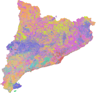
SIGPAC Catalunya 2019
| This import plan has been transformed in a manual mapping process using the original datasets as source data. |


This page describes a plan to import high quality landuse data in Catalunya (Spain) using the most updated data available from the local government.
The scope of this import (including enclaves) is 32,108 km² (12,397 sq mi), divided in 42 counties differing in sizes from 150 to 1700 km² (58 to 656 sq mi).
Datasets are shapefiles (SHP) published by county, so will be broken into 947 municipalities (0.4 to 300 km², 0.15 to 116 sq mi) in order to import them piecemeal.
On every resulting municipality, polygons with same landuses will be merged to simplify data. After that, landuse attribute will be translated into the best matching OSM tag and uploaded to the database.
Why ?
Background
In general terms, there is a lot of work to be done about landuse/landcover data in Spain.
There was an attempt to improve that situation by the Corine 2006 import done in 2011. The oversight in that import was the minor use of the released data; 45 layers were provided in the entire dataset, but only 4 layers were finally imported in Spain, corresponding to 3 forest layers based on leaf type and one more layer with olive trees coverage. For the same data, we do have some examples of full Corine imports done in some other European countries (see WikiProject_Corine_Land_Cover) like the French Corine import, where 30 layers were imported in 2009.
Relying on 2016 data, olive trees are 12% of the cultivated land in Catalonia (source), so the Corine import put aside the vast majority of agricultural areas in this region which has 66% of agricultural zones destined to arable crops. Local mappers have to deal with lack of quality of that import which was generated with a scale of 1:100000 (see Corine 2006 metadata), resulting in sharped polygons with no correlation to ground reality (see sample comparison picture). Due to the extension of the data (entire Europe), polygons were split in straight vertical oblongs that can be seen on the map renders.
Even if Corine import was supposed as a good one, it's been 13 years since the original data was generated, and we should keep in mind the changing of the land uses as time goes by. Some strong wooded areas in the Catalan Pyrenees, including national parks and nature reserves, have partial or no forest coverage. Same occurs for the main farming areas located in occidental and southern parts of Catalonia.
This situation can be vastly improved with this import.
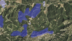
Comparison between imported data and 2018 aerial imagery.
Strong wooded areas in the catalan Pyrenees are still not well covered.
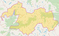
Manresa, great example of the effort done by local mappers to improve landuses.


About SIGPAC
The european regulation 1306/2013 of 17 December 2013 forced the Spanish government thru the Ministerio de Agricultura, Pesca y Alimentación (Ministry of Agriculture, Fisheries and Food) to create an identification system for agricultural parcels and aid applications from farmers with a minimum scale of 1:5000. The Spanish application of those regulations became in the creation of SIGPAC system (Sistema de Información Geográfica de Parcelas Agrícolas - Geographical Information System of Agricultural Parcels).
SIGPAC is a geographic information system, and is the only valid reference system for the identification of agricultural parcels, for the purposes of the management and control of the aid regimes established by the Community Regulation. It is also the reference system for aid schemes in which the agricultural plots must be identified. In accordance with article 3 of the Royal Decree 1077/2014, of December 19th, the SIGPAC is a public registry of an administrative nature that depends on the Spanish Agricultural Guarantee Fund and the autonomous communities.
SIGPAC in Catalonia
In the autonomous community of Catalonia, the SIGPAC system relies on both the Spanish government and the Departament d’Agricultura, Ramaderia, Pesca i Alimentació (Department of Agriculture, Livestock, Fisheries and Food) of the Generalitat de Catalunya (Government of Catalonia). In 2017, the Government of Catalonia released their SIGPAC datasets under a Open Data License. The datasets are being updated and released once a year since then.
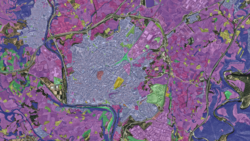
Catalan region data is digitized at 1:2000 or higher resolution using aerial imagery from the Institut Cartogràfic i Geològic de Catalunya at 25cm per pixel resolution, producing a 1:5000 scale map with minimum polygons of 20 square meters. The high level of detail can be checked on the SIGPAC 2018 render, where polygons are classified by landuse type.
The latest available dataset is the 2019 release, made with aerial imagery taken from May to October 2018 (data can be browsed here).
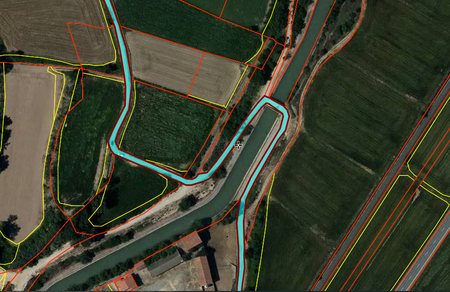
SIGPAC polygons are generated from cadastre and imagery: landuses in yellow; parcels in red.
SIGPAC 2018 sample view.

Licence
The datasets are published by under a custom Open Data License, following European Directive 2003/98/EC on the re-use of public sector information.
An explicit permission for using the datasets in OSM was granted in June 2018.
Data
The datasets can be downloaded by county from the Catalan Open Data portal. Each county dataset consists in a compressed zip file containing a shapefile (SHP) with polygon geometries. Although the files contains both cadastre parcel and landuse polygons (see picture above), only the last one is used. Using its attributes, the shapefile is divided in municipalities and later similar landuses are merged to simplify data.
The reference system is European Terrestrial Reference System 1989 (ETRS89) with UTM 31N zone (EPSG:25831). Each feature contains the following attributes:
| Field | Description |
|---|---|
| Campaign | Year that the shapefile was created. |
| ID_REC | Key attribute and unique ID that identifies an agricultural parcel. |
| ID_PAR | ID of the cadastral parcel. |
| ID_MUN | Cadastral ID of the municipality. |
| ID_COM | County ID. |
| COMARCA | County name. |
| MUNICIPI | Municipality name. |
| PRO | Numeric ID of the province |
| MUN | Numeric ID of the municipality |
| AGR | Additional Numeric ID (from cadastre; in most cases this is 0) |
| ZON | Numeric ID of the zone (in most cases this is 0) |
| POL | Numeric ID of the polygon |
| PAR | Numeric ID of the cadastral parcel |
| REC | Numeric ID of the agricultural parcel |
| US | Type of land use (23 different choices) |
| HA | Agricultural parcel area in hectares |
| SR | Irrigation coefficient (SR=0 non-irrigation and SR=100 irrigation crops) |
| CA | Coefficient of admissibility to pasture (%). Goes from 0 to 100 for the following uses: PA, PR and PS and it is fixed to 0 for other uses. |
| PV | ID of the vineyard parcel (2 letters and 3 numbers). It is only available for vineyard parcels. |
| PENDENT | Mean slope of the agricultural parcel (%) |
| REGIO | Region ID (4 digits). The first two digits refer to the region and the other two contain information on the crop group. |
Tag mapping
The ID_MUN column will be used to identify municipalities. US column will be translated to a OSM equivalent landuse tag. There are the proposed translations between tags:
| SIGPAC Landuse type | Description | Proposed OSM tag | Comment |
|---|---|---|---|
| TA | Arable land: portion of the territory destined for general herbaceous crops, stubs and fallow trees, as well as the resulting unprocessed ground of transformation of other agricultural uses. | landuse=farmland | |
| TH | Orchard: portion of the territory used for the cultivation of irrigated vegetables, vegetables and pulses. | landuse=allotments | |
| IV | Greenhouse: portion of the territory used for crops protected by glass or plastic constructions covered by plastic blankets that in any case provide plants with higher temperature than outside. | landuse=greenhouse_horticulture | |
| FY | Fruit: portion of the territory in which there is a plantation of fruit trees that can not be classified in any of the previous categories. | landuse=orchard | |
| CI | Citrus: portion of the territory in which there is a citrus plantation for the production of fruit. | landuse=orchard, trees=orange_trees | |
| FS | Nuts: portion of the territory in which there is a plantation of shell fruit trees (almond, hazelnut, walnut, pistachio or other) and carob trees for the production of dried fruit and carob. | landuse=orchard, trees=almond_trees | |
| OV | Olive: portion of the territory in which there is a plantation of olive trees for the production of fruit. | landuse=orchard, trees=olive_trees | |
| VI | Vineyard: portion of the territory where a vineyard plantation for grape production is observed. | landuse=vineyard | |
| FO | Forest: portion of the land occupied naturally by dense trees or from planting to obtain forest products, or repopulation by means of appropriate silvicultural techniques. | landuse=forest | |
| PA | Pasture with trees: portion of the land that produces fodder naturally, with a notable presence of trees. It is assigned to the enclosures generated in which a mixture of forest species, and of bushes or scrubland, or fodder with a high density of trees is appreciated. | landuse=meadow, meadow=perpetual | |
| PR | Pasture with shrubs: portion of land that produces fodder naturally, with a notable presence of shrubs. It is also assigned to the enclosures in which forest of bush or scrub is appreciated. | landuse=meadow, meadow=perpetual | |
| PS | Pastureland: portion of the territory that produces fodder in a natural or assisted way through the application of crop techniques that have not been included in the rotation of crops for five years or more. | landuse=meadow, meadow=agricultural | |
| AG | Water sources: portion of the land occupied by rivers, streams, rambles, lakes, reservoirs, etc. of natural or artificial origin, regardless of the existence of water or not at the time the area is studied. | natural=water, landuse=basin, landuse=salt_pond | Manual review due |
| OF | Olive & Fruits: mixed landuses. | landuse=orchard | |
| VO | Vineyard & Olive: mixed landuses. | landuse=orchard | |
| VF | Vineyard & Fruits: mixed landuses. | landuse=orchard | |
| FV | Nuts & Vineyard: mixed landuses. | landuse=orchard | |
| FL | Nuts & Olive: mixed landuses. | landuse=orchard | |
| ZV | Censored / Security zone: areas of the territory without information, corresponding mainly to military installations. | landuse=military | |
| ED | Buildings: constructions such as industrial and livestock buildings, houses, houses, etc. All buildings with a surface area greater than or equal to 51 m² are mapped. | No suitable tag | Won't be imported |
| ZU | Urban area: portion of land that includes a group of houses, as well as several infrastructures and spaces not dedicated to the agricultural activity. | landuse=residential, landuse=industrial | Won't be imported |
| CA | Vials: roads, regardless of size or length. | landuse=highway | Won't be imported |
| IM | Unproductive: portion of the land that due to its physical characteristics does not provide any agricultural production. | No suitable tag | Won't be imported |
Import plan
Data conflation
Most of the current landuse polygons are there since the Corine 2006 import. Due to the big difference in accuracy (minimum Corine polygons were 5 hectares, in SIGPAC they are 0.002 hectares) those polygons should be replaced by the smaller, newer ones, in order to improve to the better quality the new data has to offer.
Process
To be done by import responsibles
- The original datasets, available by counties, will be divided in municipalities using ogr2ogr and a SQLite expression. In this step, Shapefiles are converted to Geopackage format and geometry is checked for validity.
- Once all the municipalities are generated, a second ogr2ogr pass will delete all features not to be imported and keep only the useful data. Then, a Dissolve algorithm will be applied in order to simplify data and merge parcels with similar landuses.
- Each municipality file will be converted to .osm file using a Python script, applying translation tags to all polygons and creating relations/multipolygons when needed.
- With the resulting files, a task will be created in the OSM Spain Tasking Manager for each one of them.
- A list of the 947 municipalities will be available here on the wiki, where responsibles and mappers may track the import status and progress.
To be done by mappers
The main duties of the mapper will be:
- Open a task in JOSM.
- Download generated osm file from task manager.
- Run validation in order to find errors and warnings on osm generated files, and fix them to prepare data to be merged.
- Using imagery, review sensible areas like water sources.
- Download existing OSM data, and determine which one is better in terms of landuse.
- Run Validation again and fix any remaining polygon related warnings, such as overlapping, crossing ways, etc.
- Upload changes to OSM.