Southwest Surrey Mapping Party
The Southwest Surrey Mapping Party (Otherwise known as Fill The Gap III) was a past event which tool place 19th-20th April 2008.
TODO: Past tense 'what happened' information
Background
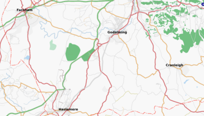
Gradually, a near-continuous swathe of mapping is forming west-south-westwards from central London down towards Bournemouth (almost 100 miles), including not only roads but also footpaths. Following the Richmond (Fill The Gap) and East Hants (Fill The Gap II) parties last year, there now exists only one significant gap, namely the area between Guildford and Hindhead/Haslemere in Surrey, around 10 miles - and even that has the main roads mapped.
http://www.openstreetmap.org/?lat=51.157&lon=-0.603&zoom=11&layers=B0FT
Aim of the party
The aim of the party (on April 19/20) then is to close that gap. Like the East Hants party I'd like to place particular emphasis on off-road mapping, namely footpaths and bridleways, with the aim to try and complete as much of the footpath network along the Hindhead-Guildford axis as possible, but there will be scope for car drivers (e.g. Godalming, complete Haslemere). If this gap is filled we will have a swathe of good mapping stretching from London all the way down to the New Forest, almost 100 miles.
What's the area like?
Despite being close to London this area is mostly rural, with just one or two small towns. It's also surprisingly hilly, Gibbet Hill reaching almost 900ft/270 metres above sea level. There are wide views across the surrounding countryside and many attractive villages; there is also extensive heathland where many of the paths are not official rights of way... so an OSM map of these areas will offer clear benefits over existing mapping!
Who should come?
As I said above I want to particularly encourage off road mapping, and this means walkers and off-road cyclists - there is plenty of scope for the latter as many (possibly most) of the rights of way in this area are bridleways. As said above there is scope for car drivers too, however, for example Godalming is not significantly mapped yet, and Haslemere is not complete.
You don't have to have a GPS as I have 4 of the OSM Foundation units.
Schedule
The meeting venue (note UPDATED), following a suggestion from 80n, is Grills and Greens in Godalming (116/118 High Street), meeting from 0930.
In case of problems my contact details (Nick W) are 07950 347717.
Each day
- 0930 Meet, breakfast and allocate areas
- 1000-1800 Mapping
- 1800-1900 Review results (venue TBC)
- 1900- Find somewhere for evening meal (Sat only)
Note that in view of the large area to be covered, there are no "formal" plans for a lunch venue. I anticipate that people mapping adjacent areas might make their own arrangements to meet for lunch.
'Cake'
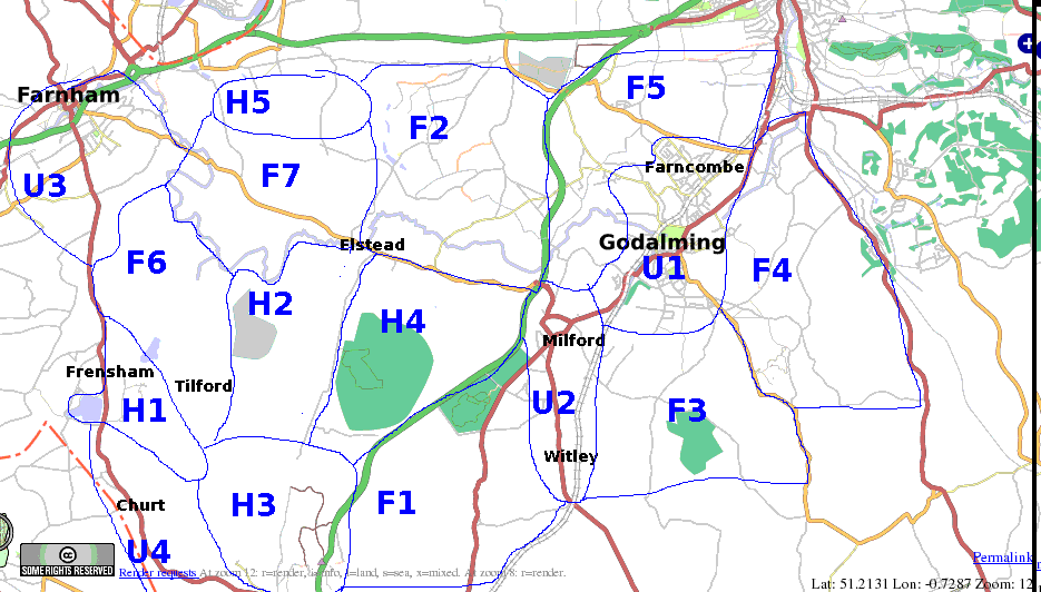
The "cake" for the day is shown below. Note the numbering system:
- Areas beginning with 'U' are urban, so the best bet for people with cars or non-off-road-suitable bikes.
- Areas beginning with 'H' are heathland. These are particularly good for off-road mapping as you can more or less wander where you like; also it will be particularly valuable to get them mapped as they contain a good number of permissive paths (not shown on the Ordnance Survey maps) in addition to the rights of way. Contain a mixture of bridleways and footpaths so can be mapped by both walkers and off-road cyclists.
- Areas beginning with 'F' are mixed farmland/woodland. They have a lower density of paths than 'H' areas, and more in the way of private land, so are likely to take longer to map as it might be difficult to locate the paths, whereas in the heathland areas you can get a lot done just by wandering randomly :-)
Detailed description of areas
Individual cake areas (OSM progress over NPE)
Urban
- U1: Godalming and Farncombe: Godalming is a medium sized market town, still with a good deal of mapping to be done towards the south and east. Most residential areas are quite pleasant.
- U2 : Milford and Witley: Villages which run into each other; generally quite pleasant. Long but narrow, doesn't extend much away from the A283.
- U3 : Farnham: large market town, not so very important to map as a bit out of the area but it's an option should you feel inclined :-)
- U4 : Hindhead, Beacon Hill and Churt: villages that run into each other. Generally very well to do, should be pleasant to map.
- U5 : Haslemere and Shottermill. Off map to the southeast, medium sized market town only partly done currently, again should generally be pleasant to map.
Heathland
- H1: Frensham Ponds and Devil's Jumps. Popular recreational area centred round two sizeable lakes, mixture of heath and pine forest. Relatively small in area compared to some of the other heathland areas.
- H2: Hankley Common. Wide and open heathland with good views towards the North Downs. Many official and permissive rights of way. Army training ground (at least was a few years ago) but likely to be open at weekends.
- H3: Devil's Punch Bowl and surroundings: Deep natural valley north of Hindhead. For people that don't mind hills :-) Mixture of heath and woodland.
- H4: Ockley/Elstead Commons. Again large numbers of bridleways and paths - notably high density of bridleways so good for off road cyclists. Could be sandy though :-) Separated from H2 by the minor road running south from Elstead.
- H5: Crooksbury Hill. Small isolated area of heathland and pine forest north of Elstead and south of the Hogs Back.
Farmland/woodland
These areas will probably take two days to complete (possibly more if you find it hard to locate the paths), or will require two people working simultaneously in the area.
- F1: Bowlhead Green/Grayswood, generally east of the A3, west of the A283, and north of Gibbet Hill.
- F2: Shackleford area, west of the A3, north of the B3001 and east of the line of longitude passing through Elstead. Partly done already.
- Note: Puttenham Common is in the northwest corner of this slice, and has many criss-crossing paths, a few of which are already on the map. This will add to the time needed to complete the slice.
- F3: Hambledon/Hydon's Ball area - east of the A283, west of the B2130, north of the greensand escarpment. Some open pine forest/heath area round Hydon's Ball. Best to focus on the southern area, near the escarpment and Hambledon, as there are a good number of paths round there.
- F4: Winkworth Arboretum area, east of the B2130, west of the A281, north of the greensand escarpment.
- F5: Compton area, south of the Hog's Back, east of the A3, west of the A3100, north of Godalming.
- F6: Tilford area. Less paths and more roads here if I remember right.
- F7: between Elstead and Farnham. Less paths and more roads here if I remember right.
Progress
U1
- South and central Godalming mapped
- Farncombe updated with more names and some roads that were unmapped
- Residential areas to West of Godalming mapped
F3
- Tuesley Lane mapped
U2
F1
- Brook visited (waiting for render)
H4
- Thursley visited again
TODO
Possibilities for further mapping in this area
- Follow the footpath stubs and see where they lead
- Trace forest areas from satellite photos
- Visit this area down New Road, and see what it's made of
- Find out what this bridge is
- Puttenham Common. Plenty of footpaths and brideways to map, plus woodland areas and the extent of the common itself.
Who's coming
Please add your name here...
- Nick W
- TimSC - I'll take F5
- Etienne
- Steve8 (Provisionally)
- Sygopet
JonobennettSorry guys -- have a poorly toddler to care for.Thomas Wood only the Saturday, probably on off-road bike, would prefer a H area, although not fussy.Cost of trains makes it prohibitive for me (also got other things to do before Monday)- Ojw + family for area U1
- Daveemtb (GPS playing up so not currently planning to attend) - Have spare GPS units - Nick W
- Robneild Probably

