Tag:amenity=refugee_site
 |
| Description |
|---|
| A human settlement sheltering refugees and/or internally displaced persons |
| Group: amenities |
| Used on these elements |
| Useful combination |
|
| See also |
| Status: approved |
| Tools for this tag |
|
The tag amenity=refugee_site is used to map a human settlement sheltering refugees and/or internally displaced persons fleeing the effects of a political crisis or a natural disaster for example. Refugee sites gather not only housing accommodation but also diverse facilities that provide services to refugees (food distribution center, outreach, NGO or government offices, warehouses, water, hygiene and sanitation facilities, etc.) along with regular human settlement related services and infrastructure.
Refugee camp (EN:Wikipedia) has a good description of what a refugee site might be.
How to map
- If the extent of the site can be clearly identified from the imagery or field data collection: It is recommended to create an area around the entire refugee site with the amenity=refugee_site tag, plus a name=* tag when possible. For a more complex multi-site facility then ideally it will be mapped using a multipolygon. There should not be a node and area for the same refugee_site. Please note this extent does not have to match the official boundary of a camp (which doesn’t necessarily coincide to its physical limitations), as defined by government and specialized agencies, for which a dedicated tag can be used.
- If the extent of the site is difficult to identify (proximity to other villages, suburban area, etc.): It is recommended to add a node in the centre of the refugee site with the amenity=refugee_site tag, plus a name=* tag when possible.
Individual building or small group of buildings like a refugee center, an accommodation center or a care and hosting center for refugees which are residential facilities for refugees should not be tagged with amenity=refugee_site but can be mapped with social_facility=shelter
Useful tag combination (optional)
Useful tag combination can be added to the main tag amenity=refugee_site to detail the typology of the camps and other valuable informations
- name=*
- alt_name=*, official_name=*, or other names.
- operator=* - name of the organisation which operates the refugee site (the operator information, if known, will allows you to differentiate between different types of refugee sites, planned, formal or informal for instance)
- operator:type=* - specifies if the operator is a NGO, community, government, or intergovernment organisation
- population=* - to indicate a rough number of refugees in the refugee site
- capacity=* -
Complementary information
Refugee vs IDP vs evacuee vs other sites
Currently there is no defined tag schema to distinguish between sites built for/by refugees, internally displaced persons, evacuees or migrants.
Current vs old refugee sites
Refugee sites are often set up as temporary emergency accommodation, but over time turn into functional, permanent settlements, e.g. [1], [2]. In some of these cases the lifecycle prefix may be used: was:amenity=refugee_site, but be aware that some of these settlements may still be formally refugee camps for decades.
Formal vs informal refugee sites
informal=yes can be used to mark sites that are not recognised by the authorities and do not have formal management agency or organisation.
Photos and examples
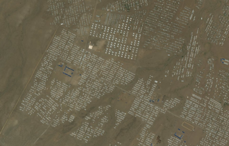
Kakuma refugee site - Kenya

- Kutupalong – Cox’s Bazar – Bangladesh refugee site an enormous camp surrounding multiple villages: https://www.openstreetmap.org/?mlat=21.2045&mlon=92.1566#map=15/21.2045/92.1566
- Tawakal refugee site - Somalia a large camp outside a town: https://www.openstreetmap.org/?mlat=6.8162&mlon=47.4566#map=16/6.8177/47.4537
- Bentiiu refugee site – South Soudan a large formal camp outside a town: https://www.openstreetmap.org/?mlat=9.3342&mlon=29.7929#map=14/9.3342/29.7929
- Moria refugee site – Greece a medium informal camp: https://www.openstreetmap.org/#map=18/39.13461/26.50351
- Elevage refugee site – Central African Republic a small camp within a town: https://www.openstreetmap.org/?mlat=5.7656&mlon=20.6886#map=15/5.7656/20.6886
See also
- amenity=social_facility + social_facility=shelter to map a single building or a small group of buildings like an accommodation center or a care and hosting center. social_facility:for=refugee is likely to be applicable
- Proposed features/Refugee Site Location 2
- amenity=refugee_housing - deprecated schema
- Tag:refugee=yes - proposed, but never approved schema
- Refugee Camp Mapping - description on mapping details within refugee camps (sites) relying on the older amenity=social_facility + social_facility=shelter + social_facility:for=migrant schema