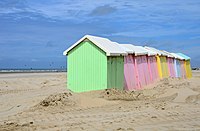
Tag:building=beach_hut
Jump to navigation
Jump to search
| Description |
|---|
| A beach hut: small, usually wooden, and often brightly coloured cabin or shelter above the high tide mark on popular bathing beaches. |
| Rendering in OSM Carto |

|
| Group: buildings |
| Used on these elements |
| Useful combination |
| See also |
| Status: in use |
| Tools for this tag |
|
A ![]() beach hut (also known as a bathing box) is a small, usually wooden, and often brightly coloured structure used by beachgoers to change clothes, store belongings or generally enjoy the beach.
beach hut (also known as a bathing box) is a small, usually wooden, and often brightly coloured structure used by beachgoers to change clothes, store belongings or generally enjoy the beach.
Unlike a building=hut, a beach hut is generally well-constructed and not permanently occupied. The often bright colours of beach huts can serve as a local landmarks, and privately owned beach houses are often sought after real estate.
How to map
Draw an area marking this feature. Tag it with building=beach_hut.
It is also OK to set a node at its center, if mapping as area is impossible.
See also
- building=hut - A small and crude shelter (or dwelling).
- building=shed - A simple, single-storey structure that is used for storage, hobbies, or as a workshop.
- amenity=shelter - A small structure designed to protect against bad weather conditions.
