User:Uroesch
| Babel user information | ||
|---|---|---|
| ||
| Users by language |
I used to do pretty much all my mapping on foot or occasionally by bicycle when I was based in Futakotamagawa. Since I moved back to Switzerland my mapping is mostly by bicycle.
My Mapping Techniques
Tools
- Editor: Merkaartor
- GPS Unit (Walking): Garmin etrex Vista HCx
- GPS Unit (Riding): Holux M-241
- Conversion (Garmin): GPSbabel
- Conversion (Holux): BT747
- Garmin Maps: Home grown scripts
- Map Lint: Keep Right
Trace File Naming Conventions
I try to name my files so I can remember where and when they were taken. Since I do most of my mapping on foot or by bicycle the range is rather small and the method described below works for me.
<Country>_<Administrative Division>_<Place>_YYYYMMDD_HHMM.gpx
e.g.
Japan_Tokyo_Futakotamagawa_20090131_1530.gpx
Switzerland_Aargau_Koblenz_20090717_1530.gpx
For Tokyo the place is the closest station as this is easier to pinpoint later where the trace started.
Mapping Guidelines
- Guideline 1
- Walk without too many turns. I think it yields a better GPS track.
- Guideline 2
- Walk the street to the end or until the next large road. That way you I don't have to come back again to finish it :)
- Guideline 3
- Map white spots and cover as much ground as possible.
- Guideline 4
- Update the map of the GPS unit daily to avoid duplication.
- Guideline 5
- Only map more details (POIs) when going back to a place regularly.
Focus Areas
Achenberg and surroundings
I try to get up way before my wife and son drag themselves out of bed, get on my bicycle and run up the Achenberg or some of the forest bordering it.
Koblenz, AG
I'm back in my home town after a long, long time and take the time to finish some loose ends.
Status
Map Compare
Past Areas of Interest
Setagaya
Did a lot of walking around the area by taking detours on my way back from work and hop of at another station walk the streets that have not been surveyed yet. The limit was to the north is the Odakyu line (see picture for better overview)
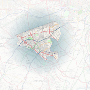
Area in Setagaya-ku I'm trying to map.

Kinuta Park
For a long time I focused on Kinuta Park as it was in my neighbourhood and it was perfect to spend time with the family. At some point the visits became fewer. The remaining parts of the park should like the buildings should be doable with the help of Bing.
Todo
Dog Trail (100% done)Wood (100% done)River (100% done)Bird Sanctuary Lake (100% done)- Kiosks (1 missing) <- use Bing
- Fences (5% done)
- Playground details (0% done)
- Admin buildings (0% done)
- Labeling all the areas (10% done)
- Benches (10% done)
- Water fountains (0% done)
Map Compare
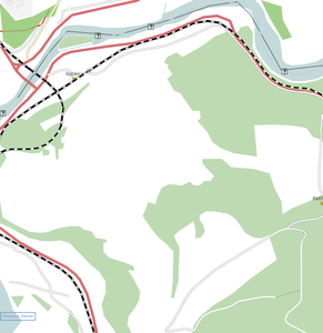
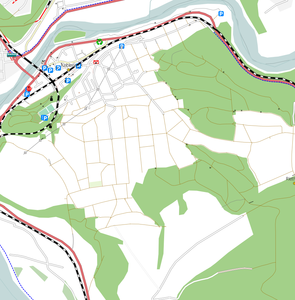
Kinuta Park when taking it under my wings

Kinuta Park when I first set foot on it.

Kobe, Japan
Did some mapping in Kobe over the 2010 Golden Week vacation. Kobe was still pretty bare compared to other large cities in Japan at that point in time.
Went back for another short vacation in June 2010 and added more details. The activities this time included a few bus rides to various places.
There is another trip planned for October 2010 so I hope to get more streets mapped.
Koblenz, AG - Vacation project
During my summer vacation 2009 I mapped my home town. I think the results are quite good. Still missing the house numbers and there are no good satellite images for Switzerland to really complete the job.
In 2010 I went back for another vacation and I added house numbers (with the exeption of the farmhouses) and the streams (complete with the exception of the one going into the Giritz). I also expanded largely on the power lines, poles and towers but there are still some gaps for the line from Kraftwerk Klingnau to Bad Zurzach (Kli-Zu) where only a few poles are maped.
Before / After comparison for 2009 vacation
Koblenz, Switzerland before 2009 summer vacation
Koblenz, Switzerland after 2009 summer vacation


Random Bits and Pieces
Mount Fuji
2009 Hike
Did climb Mount Fuji in August of 2009. Giving my then shiny new Garmin gear a little endurance test. During descent I took a wrong turn instead of going down the Yoshida trail I ended up on the Subashiri one. At the 5th station I was in Shizuoka prefecture rather than on the expected Yamanashi side. Luckily for OSM someone else did do the Yoshida trail around the same time so we ended up with more data :).
2010 Hike
Did another hike up Mount Fuji this time with a tad more prepration. To make the trip more useful for OSM I choose the Gotemba trail for the ascent and the Fujinomiya one for the descent. Starting at the New Gotemba 5th station there was a lot of fog which lasted nearly up 2500m above sea level and I got of the track twice. But after getting above the clouds the weather was gorgeous and the data should be very accurate.
Map Compare
Hakone
Mapped some of the tourist ship routes on Lake Ashinoko during a one day trip.