Washington Metro
The DC GIS has shapefiles with the Washington Metro lines, stations, and even details like subway entrances, with the data including the entire system and not just what's within DC proper. The District of Columbia has shown willingness to let OpenStreetMap use the data in DC GIS. However, the DC GIS sources the Metro data from WMATA (Washington Metropolitan Area Transit Authority), which is the real copyright holder. We would need their permission, in addition to permission from DC GIS.
For now, we can plunge forward with mapping the metro lines, stations, and bus routes ourselves.
Metro lines
We want to map the metro lines, where they physically go, along with each of the stations. Portions of the Red Line and other lines are above ground, and can be mapped with GPS tracks and/or tracing from the aerial imagery.
Large sections of the metro lines are underground in tunnels. How do we map these, when GPS does not work in tunnels?
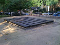
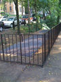
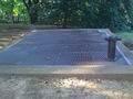
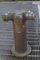
For safety reasons, the metro tunnels include emergency exits located between stations, with the exception of some segments where the distance between stations is short (e.g. between Gallery Place and Metro Center). The tunnels also feature numerous ventilation shafts, fire standpipes, power substations, and other above-ground infrastructure. It is possible to identify these and map these with GPS, or locate and then map from aerial imagery.
With the ventilation shafts and infrastructure mapped, along with the stations, that provides enough nodes to interpolate and map the metro lines. There obviously are no sharp turns on the metro lines. There are only gradual curves and straight lines.
General knowledge can also be used in mapping the lines. For example, it's known that the Red Line:
- is located beneath Georgia Avenue from Forest Glen to Glenmont
- follows along Wisconsin Avenue / Rt 355 from Tenleytown all the way up to Shady Grove
- the Red Line goes beneath Yuma St NW, when it cuts across from Van Ness (on Connecticut Avenue) to Tenleytown (on Wisconsin Avenue)
The following text is from a (public domain) US House of Representatives appropriation report, and details the routes from the mid-1970s, soon before opening of the first section:
- A. Rockville Route: This route starts at the east end of the Metro Center Station; runs westerly under G Street; northwest under Connecticut Avenue to Van Ness Street; west under Yuma Street; northwest under Wisconsin Avenue to the vicinity of Randolph Road; northwest along the C&O/B&O Railroad right-of-way to Park Road in Rockville.
- B. Glenmont Route: This route starts at the east end of the Metro Center Station; runs easterly under G Street; east under D Street; northeast adjacent to Union Station; north between the C&O/B&O Railroad tracks to Silver Spring; north under 16th Street (extended) and Georgia Avenue to Denley Road.
- C. Huntington Route: This route starts at the south end of the Metro Center Station; runs north under 12th Street to Eye Street, N.W.; west under Eye Street to the Potomac River; west under the river to Rosslyn; south through Rosslyn by subway, then on surface and again in subway to the Pentagon and Pentagon City; east under 18th Street; south through National Airport on aerial structure and surface; continues south along the RF&P Railroad right-of-way through Alexandria to Duke Street; south on aerial structure and surface to Kings Highway.
- D. New Carrollton Route: This route starts at the south end of the Metro Center Station; runs south under 12th Street; crosses the Mall; runs east under D Street, S.W.; southeast under Pennsylvania Avenue, S.E.; east under G Street; northeast under Potomac Avenue, S.E.; north under 19th Street, S.E.; northeast across R.F. Kennedy Stadium parking lot; crosses Anacostia River near Benning Road Bridge to Kenilworth Avenue, N.E.; northeast on surface along the Penn Central Transportation Company right-of-way to a point midway between John Hanson Highway and the Capital Beltway.
- E. Greenbelt Route: This route starts at the north end of the Gallery Place Station; runs north under 7th Street, N.W.; west under U Street, N.W.; north under 14th Street, N.W.; northeast under Kansas Avenue; east under Farragut Street; northeasterly on surface, east under East-West Highway; northeast under Queens Chapel Road; northerly on surface along the C&O/B&O Railroad right-of-way to Kenesaw Street.
- [This route was later modified between Columbia Heights and Prince George's Plaza.]
- F. Branch Route: This route starts at the north end of the Gallery Place Station; runs south under 7th Street, N.W.; under the Mall; east under M Street, S.W.; under the Washington Navy Yard; under the Anacostia River in sunken tube; southeast under Good Hope Road; southeast under Naylor Road; on surface along Suitland Parkway, past the Federal Center; southerly on surface to Branch Avenue near the Capital Beltway.
- [This route was later modified between Navy Yard and Naylor Road.]
- G. Addison Route: This route starts at a turnout from the New Carrollton Route in the vicinity of Benning Road and Kenilworth Avenue, N.E.; runs southeast under Fort Mahan Park and Benning Road; east under East Capitol Street; southeast adjacent to Central Avenue to Cindy Lane.
- H. Franconia Route: This route starts at a turnout from the Backlick Route [sic-renamed Springfield Route] in the vicinity of Tilbury Road and the Capital Beltway and runs south on the surface to Franconia Road.
- J. Springfield Route: This route starts at a turnout from the Huntington Route in the vicinity of Duke Street; runs west on surface along the RF&P Railroad right-of-way; west along the Southern Railroad right-of-way to Backlick Road.
- [This route was not built west of the Franconia Route turnout.]
- K. Vienna Route: This route starts at a turnout from the Huntington Route south of the Rosslyn Station in the vicinity of North Lynn Street; runs under and adjacent to 16th Street; under private property to Fillmore Street, under and adjacent to Wilson Boulevard; under and adjacent to Fairfax Drive; surface within the median of I-66 to west of Nutley Road.
- L. L'Enfant Plaza - Pentagon Route: This route starts at a turnout from the Branch Route south of the L'Enfant Plaza Station in the vicinity of 7th Street S.W. and Frontage Road; under the Washington Channel in sunken tube; over the Potomac River on bridge; under the Shirley Highway (I-95) in subway, to a turnout to the Huntington Route northwest of the Pentagon Station in the vicinity of Jefferson Davis Highway.
Stations
For each station, we want details including:
- subway entrances - mark these with attributes "elevator=yes", "escalator=yes", "steps=yes"?
- platform
- parking
- bus station
- pedestrian areas
- service roads
- other attributes?
Red Line
Done
To-do
- From Takoma to Union Station
- From Union Station to Farragut North
- From Farragut North to Tenleytown
- From Tenleytown to Shady Grove
Images
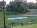
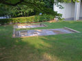
Locations (mapped nodes) between Silver Spring and Forest Glen. Think that I got them all in this segment. --Kate (talk) 20:15, 11 August 2009 (UTC)
Noyes Lane
16th St
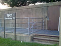
Seminary Pl
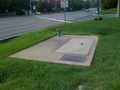
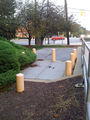
Beltway vent
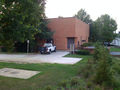
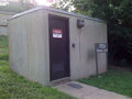
Elevator building
Forest Glen Rd


Some mapped nodes on the Red Line, between Dupont Circle and Bethesda. This is only a small number of them, though we may not need each one since we can assume that the Red Line goes beneath Connecticut Avenue between Woodley Park and Van Ness, and it goes beneath Wisconsin Avenue / Rt 355 north of Tenleytown:
Belmont Rd. exit
Belmont Rd. vent
Yuma St. vent (35th St)
Yuma St. vent (38th St)
Yuma St. standpipe (38th St)
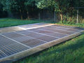
Wisconsin Avenue, in Chevy Chase/Bethesda, near country club


Stations
- Glenmont
- Wheaton
- don't rely on the aerial imagery, the Wheaton station has been reconfigured in the past couple years
- Forest Glen
- Silver Spring
- Takoma
- Fort Totten
- Brookland
- Rhode Island Avenue
- New York Avenue
- Union Station
- Jucidiary Square
- Gallery Pl-Chinatown
- Metro Center
- Farragut North
- Dupont Circle
- Woodley Park
- Cleveland Park
- Van Ness
- Tenleytown
- Friendship Heights
- Bethesda
- Medical Center
- Grosvenor
- White Flint
- Twinbrook
- Rockville
- Shady Grove
Green Line
Stations
- Greenbelt
- College Park
- Prince George's Plaza
- West Hyattsville
- Fort Totten
- Georgia Avenue-Petworth
- Columbia Heights
- U Street
- Shaw
- Mount Vernon Square
- Gallery Pl-Chinatown
- Archives
- L'Enfant Plaza
- Waterfront
- Navy Yard
- Anacostia
- Congress Heights
- Southern Avenue
- Naylor Road
- Suitland
- Branch Avenue
Yellow Line
Stations
- Huntington
- Eisenhower Avenue
- King Street
- Braddock Road
- National Airport
- Crystal City
- Pentagon City
- Pentagon
- L'Enfant Plaza
- Archives
- Gallery Pl-Chinatown
- Mount Vernon Square
Blue Line
Stations
- Franconia-Springfield
- Van Dorn Street
- King Street
- Braddock Road
- National Airport
- Crystal City
- Pentagon City
- Pentagon
- Arlington Cemetery
- Rosslyn
- Foggy Bottom
- Farragut West
- McPherson Square
- Metro Center
- Federal Triangle
- Smithsonian
- L'Enfant Plaza
- Federal Center
- Capitol South
- Eastern Market
- Potomac Avenue
- Stadium-Armory
- Benning Road
- Capitol Heights
- Addison Road
- Morgan Boulevard
- Largo Town Center
Orange Line
Stations
- Vienna
- Dunn Loring
- West Falls Church
- East Falls Church
- Ballston
- Virginia Square
- Clarendon
- Court House
- Rosslyn
- Foggy Bottom
- Farragut West
- McPherson Square
- Metro Center
- Federal Triangle
- Smithsonian
- L'Enfant Plaza
- Federal Center
- Capitol South
- Eastern Market
- Potomac Avenue
- Stadium-Armory
- Benning Road
- Capitol Heights
- Addison Road
- Morgan Boulevard
- Largo Town Center
Silver Line
Stations
- Wiehle-Reson
- Spring Hill
- Greensboro
- Tysons Corner
- McLean
- East Falls Church
- Ballston-MU
- Virginia Square-GMU
- Clarendon
- Court House
- Rosslyn
- Foggy Bottom
- Farragut West
- McPherson Square
- Metro Center
- Federal Triangle
- Smithsonian
- L'Enfant Plaza
- Federal Center
- Capitol South
- Eastern Market
- Potomac Avenue
- Stadium-Armory
- Benning Road
- Capitol Heights
- Addison Road
- Morgan Boulevard
- Largo Town Center
Bus routes
Metro
Circulator
- Possible to import from DC GIS?
Suburban bus systems
- Montgomery County Ride-On
Commuter rail
MARC and VRE have additional rail stations, some which also are served by Amtrak.
- MARC (Maryland)
- VRE (Virginia)