YOLO crossings import
YOLO crossings import is an import of pedestrian zebra-crossings detected from orthophoto imagery.
The import is currently (as of 2023-08) in progress and covers the area of Poland.
Please read here for up-to-date information about this import.
The import is uploaded from the ![]() NorthCrab_upload (on osm) account.
NorthCrab_upload (on osm) account.
Goals
The goal of this project is to enhance the OpenStreetMap database with pedestrian crossing data using an AI model.
The tool aims to provide high precision results, minimizing false positives, and reducing manual mapping efforts.
Schedule
The project is ongoing, with updates being made as the AI tool is refined and new data becomes available.
Import Data
Background
Data source site: https://www.geoportal.gov.pl/dane/ortofotomapa
Data license: https://www.geoportal.gov.pl/regulamin
Type of license: Pl:Geoportal.gov.pl
OSM attribution: source=aerial imagery
ODbL Compliance verified: yes
OSM Data Files
The script preparing data for import can be found in the GitHub repository.
Import Type
This is a recurring import that is performed using an automated script.
The data is entered into the OSM database using the OSM API.
Data Preparation
Data Reduction & Simplification
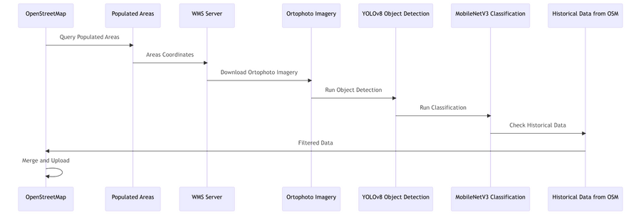
Please refer to this application diagram:
Tagging Plans
| Key | Value |
|---|---|
| crossing:markings | zebra |
| highway | crossing |
Data Transformation
The data is transformed using a Python script, which can be found in the GitHub repository.
Data Transformation Results
There are no exact data transformation results. The data is transformed on-demand.
Data Merge Workflow
Team Approach
This import is being performed by a single individual, with community input and discussion.
References
All references are included in the related text as hyperlinks.
Workflow
- Filter populated areas using Overpass API.
- Retrieve and preprocess orthophoto imagery for each road.
- Use an object detection AI model to detect regions of interest (potential crossings).
- Use a classification AI model to confirm crossings in each detected region.
- Verify historical OSM data to identify previously deleted crossings.
- Import new crossings into OSM.
Changesets will be kept to a manageable size, and any issues that arise will be addressed promptly.
Conflation
Any crossings that already exist in OSM database are skipped.
QA
Quality assurance is performed in several steps:
- During the model creation, manually classified data is split into training and testing datasets. The precision of the model is measured on the test data prior to production release.
- Some changesets are manually verified by the community.
