Ko:Tag:landuse=meadow
Jump to navigation
Jump to search
![]()
이 문서는 번역본이지만 번역이 완전하지 않고 빠지거나 잘못 되거나 아직 번역되지 않은 부분이 있습니다.
영어 원본의 내용을 이해할 수 있다면 번역 완료에 힘을 모아 주십시오. 번역 방법에 대해서는 위키 번역 방법에 대한 설명을 읽어주시길 바랍니다. 만약 이 문서의 번역이 충분하다고 판단되면 이 틀을 지워주시길 바랍니다.
이 즈음에는 맡아서 번역을 하는 사람이 없기 때문에, 당신이 이 작업을 해 줄 수 있습니다.
영어 원본의 내용을 이해할 수 있다면 번역 완료에 힘을 모아 주십시오. 번역 방법에 대해서는 위키 번역 방법에 대한 설명을 읽어주시길 바랍니다. 만약 이 문서의 번역이 충분하다고 판단되면 이 틀을 지워주시길 바랍니다.
이 즈음에는 맡아서 번역을 하는 사람이 없기 때문에, 당신이 이 작업을 해 줄 수 있습니다.
![]()
 |
| 설명 |
|---|
| 풀밭, 초원 또는 목초지: 주로 풀과 기타 나무가 아닌 식물이 자라는 땅으로, 주로 꼴이나 여물, 방목에 씁니다. |
| OSM Carto에서 렌더링 |

|
| 그룹: 토지 이용 |
| 해당 요소의 사용 |
| 유용한 조합 |
| 같이 보기 |
| 상태:사실상 표준 |
| 이 태그를 위한 도구 |
풀밭, 초원 또는 목초지를 태그하는 데에 씁니다. 주로 풀과 기타 나무가 아닌 식물이 자라는 토지로, 주로 꼴이나 여물 또는 동물 방목을 위해 씁니다.
How to map
Draw a way around the area of the meadow, and tag landuse=meadow.
Tags in combination
If the meadow or pasture has a name, add name="name of meadow".
The key meadow=* has been used to indicate the process that protects the meadow status, or the kind of meadow.
- meadow=agricultural a hay meadow or pasture, maintained by cutting, mowing or grazing.
- meadow=transitional an area of grass which is transitioning to heath, scrub or woodland.
- meadow=perpetual a "meadow" which is retained by natural factors. (It is more common to use natural=grassland in this case)
- meadow=pasture a pasture for grazing livestock (not a hay meadow).
- meadow=paddock an area of grass where horses or other animals are kept
- meadow=meadow_orchard an area which is both an orchard (with trees grown for fruit or nuts) and a meadow. (Also see orchard=meadow_orchard + landuse=orchard)
- meadow=wildflower A wildflower meadow. It serves primarily as a habitat for insects and for nature conservation rather than for the production of grass and hay. It is also usually regularly mown.
Photos
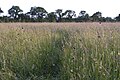
Long grassy meadow
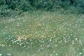
Cut meadow

.jpg)
Rendering example

See also
- landuse=farmland - An area of farmland used for tillage (cropland). This tag is sometimes also used for pasture or meadow.
- landuse=grass - An area of mown and managed grass, e.g. a lawn in a park, part of a golf course, roadside verges etc.
- surface=grass - To indicate the surface of a specific use feature e.g. leisure=pitch
- landcover=grass.
- natural=grassland - An area of non-cultivated grassland.
- natural=scrub - A plant community characterized by vegetation dominated by shrubs (bush) More woody plants than a meadow or grassland.
- natural=heath - A dwarf-shrub habitat, characterised by open, low growing woody vegetation, often dominated by plants of the Ericaceae. More woody plants than a meadow or grassland.
- Vegetation - summary of tags related to areas of vegetation of different types
Tagging mistakes
External links
| ||||||||||||||||||||||||||||||||